You are here: Home > Network List > GE - GEOFON Stations List
> Station MALT GEOFON/MedNet Station Malatya, Turkey > Earthquake Result Viewer
MALT GEOFON/MedNet Station Malatya, Turkey - Earthquake Result Viewer
| Earthquake location: |
Kuril Islands |
| Earthquake latitude/longitude: |
45.4/149.3 |
| Earthquake time(UTC): |
2006/06/22 (173) 10:53:11 GMT |
| Earthquake Depth: |
95 km |
| Earthquake Magnitude: |
6.1 MB, 6.0 MW, 5.9 MW |
| Earthquake Catalog/Contributor: |
WHDF/NEIC |
|
| Network: |
GE GEOFON |
| Station: |
MALT GEOFON/MedNet Station Malatya, Turkey |
| Lat/Lon: |
38.31 N/38.43 E |
| Elevation: |
1120 m |
|
| Distance: |
76.1 deg |
| Az: |
310.797 deg |
| Baz: |
42.673 deg |
| Ray Param: |
0.051013403 |
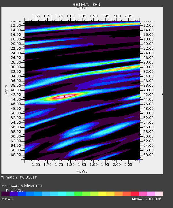
| Estimated Moho Depth: |
42.5 km |
| Estimated Crust Vp/Vs: |
1.77 |
| Assumed Crust Vp: |
6.35 km/s |
| Estimated Crust Vs: |
3.583 km/s |
| Estimated Crust Poisson's Ratio: |
0.27 |
|
| Radial Match: |
90.83619 % |
| Radial Bump: |
400 |
| Transverse Match: |
85.21542 % |
| Transverse Bump: |
400 |
| SOD ConfigId: |
2665 |
| Insert Time: |
2010-03-09 06:43:50.688 +0000 |
| GWidth: |
2.5 |
| Max Bumps: |
400 |
| Tol: |
0.001 |
|

Signal To Noise
| Channel | StoN | STA | LTA |
| GE:MALT: :BHN:20060622T11:04:17.879021Z | 16.795906 | 7.8591444E-7 | 4.679202E-8 |
| GE:MALT: :BHE:20060622T11:04:17.879021Z | 4.1552415 | 5.081109E-7 | 1.2228192E-7 |
| GE:MALT: :BHZ:20060622T11:04:17.879021Z | 49.03753 | 3.1210295E-6 | 6.3645736E-8 |
| Arrivals |
| Ps | 5.3 SECOND |
| PpPs | 18 SECOND |
| PsPs/PpSs | 23 SECOND |


