You are here: Home > Network List > NX - Nanometrics Research Network Stations List
> Station WTX29 Z > Earthquake Result Viewer
WTX29 Z - Earthquake Result Viewer
| Earthquake location: |
Near East Coast Of Honshu, Japan |
| Earthquake latitude/longitude: |
38.5/141.6 |
| Earthquake time(UTC): |
2021/03/20 (079) 09:09:45 GMT |
| Earthquake Depth: |
54 km |
| Earthquake Magnitude: |
7.0 Mww |
| Earthquake Catalog/Contributor: |
NEIC PDE/us |
|
| Network: |
NX Nanometrics Research Network |
| Station: |
WTX29 Z |
| Lat/Lon: |
32.74 N/103.56 W |
| Elevation: |
1207 m |
|
| Distance: |
86.8 deg |
| Az: |
49.997 deg |
| Baz: |
314.486 deg |
| Ray Param: |
0.043690383 |
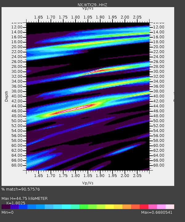
| Estimated Moho Depth: |
44.75 km |
| Estimated Crust Vp/Vs: |
1.80 |
| Assumed Crust Vp: |
6.129 km/s |
| Estimated Crust Vs: |
3.4 km/s |
| Estimated Crust Poisson's Ratio: |
0.28 |
|
| Radial Match: |
90.57576 % |
| Radial Bump: |
400 |
| Transverse Match: |
70.07972 % |
| Transverse Bump: |
400 |
| SOD ConfigId: |
24334971 |
| Insert Time: |
2021-04-03 09:35:01.114 +0000 |
| GWidth: |
2.5 |
| Max Bumps: |
400 |
| Tol: |
0.001 |
|

Signal To Noise
| Channel | StoN | STA | LTA |
| NX:WTX29: :HHZ:20210320T09:21:52.620003Z | 2.499148 | 6.668767E-7 | 2.6684162E-7 |
| NX:WTX29: :HHN:20210320T09:21:52.620003Z | 1.0353622 | 2.1832832E-7 | 2.1087143E-7 |
| NX:WTX29: :HHE:20210320T09:21:52.620003Z | 1.8225815 | 2.9255045E-7 | 1.6051433E-7 |
| Arrivals |
| Ps | 6.0 SECOND |
| PpPs | 20 SECOND |
| PsPs/PpSs | 26 SECOND |


