You are here: Home > Network List > O2 - Oklahoma Consolidated Temporary Seismic Networks Stations List
> Station CHAN Chandler, Oklahoma, USA > Earthquake Result Viewer
CHAN Chandler, Oklahoma, USA - Earthquake Result Viewer
| Earthquake location: |
Near East Coast Of Honshu, Japan |
| Earthquake latitude/longitude: |
38.5/141.6 |
| Earthquake time(UTC): |
2021/03/20 (079) 09:09:45 GMT |
| Earthquake Depth: |
54 km |
| Earthquake Magnitude: |
7.0 Mww |
| Earthquake Catalog/Contributor: |
NEIC PDE/us |
|
| Network: |
O2 Oklahoma Consolidated Temporary Seismic Networks |
| Station: |
CHAN Chandler, Oklahoma, USA |
| Lat/Lon: |
35.65 N/96.79 W |
| Elevation: |
266 m |
|
| Distance: |
88.6 deg |
| Az: |
43.932 deg |
| Baz: |
318.035 deg |
| Ray Param: |
0.042377684 |
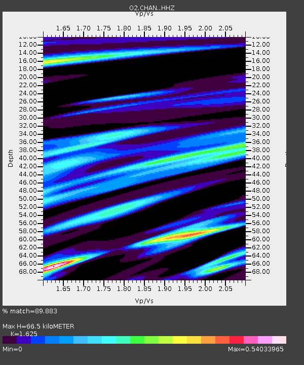
| Estimated Moho Depth: |
66.5 km |
| Estimated Crust Vp/Vs: |
1.62 |
| Assumed Crust Vp: |
6.426 km/s |
| Estimated Crust Vs: |
3.955 km/s |
| Estimated Crust Poisson's Ratio: |
0.20 |
|
| Radial Match: |
89.883 % |
| Radial Bump: |
262 |
| Transverse Match: |
76.25566 % |
| Transverse Bump: |
274 |
| SOD ConfigId: |
24334971 |
| Insert Time: |
2021-04-03 09:35:10.836 +0000 |
| GWidth: |
2.5 |
| Max Bumps: |
400 |
| Tol: |
0.001 |
|

Signal To Noise
| Channel | StoN | STA | LTA |
| O2:CHAN: :HHZ:20210320T09:22:01.154977Z | 5.751299 | 2.4299554E-6 | 4.2250554E-7 |
| O2:CHAN: :HHN:20210320T09:22:01.154977Z | 1.2828361 | 7.618917E-7 | 5.93912E-7 |
| O2:CHAN: :HHE:20210320T09:22:01.154977Z | 1.3239243 | 6.4141216E-7 | 4.84478E-7 |
| Arrivals |
| Ps | 6.6 SECOND |
| PpPs | 27 SECOND |
| PsPs/PpSs | 33 SECOND |


