You are here: Home > Network List > O2 - Oklahoma Consolidated Temporary Seismic Networks Stations List
> Station FW07 Waynoka, Oklahoma, USA > Earthquake Result Viewer
FW07 Waynoka, Oklahoma, USA - Earthquake Result Viewer
| Earthquake location: |
Near East Coast Of Honshu, Japan |
| Earthquake latitude/longitude: |
38.5/141.6 |
| Earthquake time(UTC): |
2021/03/20 (079) 09:09:45 GMT |
| Earthquake Depth: |
54 km |
| Earthquake Magnitude: |
7.0 Mww |
| Earthquake Catalog/Contributor: |
NEIC PDE/us |
|
| Network: |
O2 Oklahoma Consolidated Temporary Seismic Networks |
| Station: |
FW07 Waynoka, Oklahoma, USA |
| Lat/Lon: |
36.45 N/98.80 W |
| Elevation: |
404 m |
|
| Distance: |
86.9 deg |
| Az: |
44.599 deg |
| Baz: |
316.88 deg |
| Ray Param: |
0.043619797 |
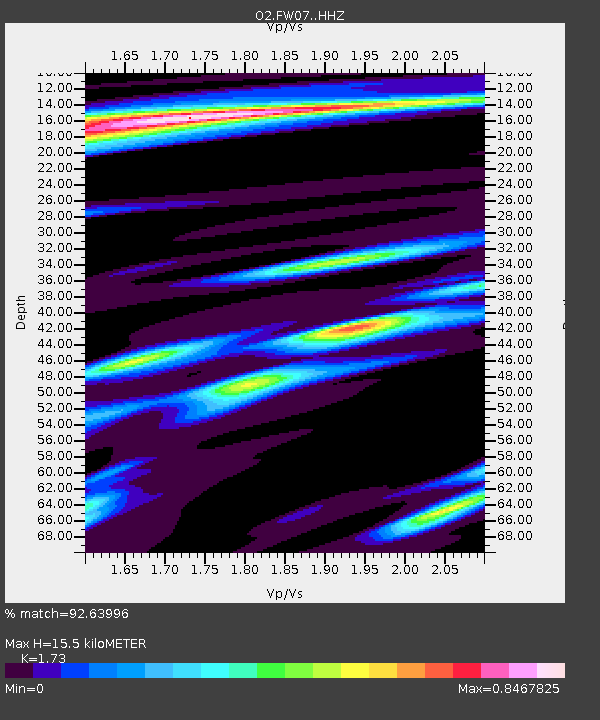
| Estimated Moho Depth: |
15.5 km |
| Estimated Crust Vp/Vs: |
1.73 |
| Assumed Crust Vp: |
6.426 km/s |
| Estimated Crust Vs: |
3.715 km/s |
| Estimated Crust Poisson's Ratio: |
0.25 |
|
| Radial Match: |
92.63996 % |
| Radial Bump: |
288 |
| Transverse Match: |
82.20013 % |
| Transverse Bump: |
383 |
| SOD ConfigId: |
24334971 |
| Insert Time: |
2021-04-03 09:35:28.735 +0000 |
| GWidth: |
2.5 |
| Max Bumps: |
400 |
| Tol: |
0.001 |
|

Signal To Noise
| Channel | StoN | STA | LTA |
| O2:FW07: :HHZ:20210320T09:21:53.089974Z | 5.1727095 | 2.6472649E-6 | 5.117753E-7 |
| O2:FW07: :HHN:20210320T09:21:53.089974Z | 2.6115763 | 1.3309042E-6 | 5.096172E-7 |
| O2:FW07: :HHE:20210320T09:21:53.089974Z | 0.6722165 | 4.110178E-7 | 6.1143663E-7 |
| Arrivals |
| Ps | 1.8 SECOND |
| PpPs | 6.4 SECOND |
| PsPs/PpSs | 8.2 SECOND |


