You are here: Home > Network List > O2 - Oklahoma Consolidated Temporary Seismic Networks Stations List
> Station PW02 Pawnee, Oklahoma, USA > Earthquake Result Viewer
PW02 Pawnee, Oklahoma, USA - Earthquake Result Viewer
| Earthquake location: |
Near East Coast Of Honshu, Japan |
| Earthquake latitude/longitude: |
38.5/141.6 |
| Earthquake time(UTC): |
2021/03/20 (079) 09:09:45 GMT |
| Earthquake Depth: |
54 km |
| Earthquake Magnitude: |
7.0 Mww |
| Earthquake Catalog/Contributor: |
NEIC PDE/us |
|
| Network: |
O2 Oklahoma Consolidated Temporary Seismic Networks |
| Station: |
PW02 Pawnee, Oklahoma, USA |
| Lat/Lon: |
36.42 N/96.86 W |
| Elevation: |
314 m |
|
| Distance: |
88.0 deg |
| Az: |
43.465 deg |
| Baz: |
317.979 deg |
| Ray Param: |
0.042830873 |
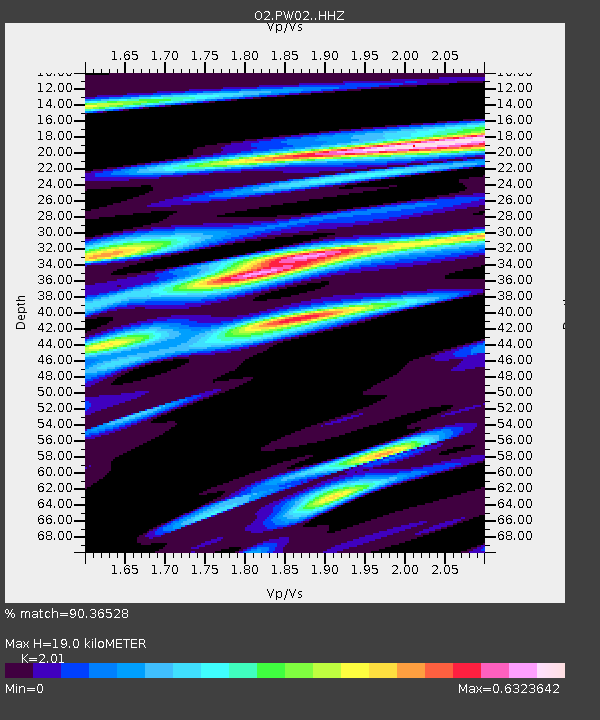
| Estimated Moho Depth: |
19.0 km |
| Estimated Crust Vp/Vs: |
2.01 |
| Assumed Crust Vp: |
6.483 km/s |
| Estimated Crust Vs: |
3.225 km/s |
| Estimated Crust Poisson's Ratio: |
0.34 |
|
| Radial Match: |
90.36528 % |
| Radial Bump: |
310 |
| Transverse Match: |
64.48426 % |
| Transverse Bump: |
400 |
| SOD ConfigId: |
24334971 |
| Insert Time: |
2021-04-03 09:35:42.113 +0000 |
| GWidth: |
2.5 |
| Max Bumps: |
400 |
| Tol: |
0.001 |
|

Signal To Noise
| Channel | StoN | STA | LTA |
| O2:PW02: :HHZ:20210320T09:21:58.284981Z | 4.6262574 | 1.9860713E-6 | 4.2930412E-7 |
| O2:PW02: :HHN:20210320T09:21:58.284981Z | 1.8847712 | 1.186225E-6 | 6.2937346E-7 |
| O2:PW02: :HHE:20210320T09:21:58.284981Z | 1.4169779 | 7.1863394E-7 | 5.071596E-7 |
| Arrivals |
| Ps | 3.0 SECOND |
| PpPs | 8.7 SECOND |
| PsPs/PpSs | 12 SECOND |


