You are here: Home > Network List > O2 - Oklahoma Consolidated Temporary Seismic Networks Stations List
> Station PW13 Pawnee, Oklahoma, USA > Earthquake Result Viewer
PW13 Pawnee, Oklahoma, USA - Earthquake Result Viewer
| Earthquake location: |
Near East Coast Of Honshu, Japan |
| Earthquake latitude/longitude: |
38.5/141.6 |
| Earthquake time(UTC): |
2021/03/20 (079) 09:09:45 GMT |
| Earthquake Depth: |
54 km |
| Earthquake Magnitude: |
7.0 Mww |
| Earthquake Catalog/Contributor: |
NEIC PDE/us |
|
| Network: |
O2 Oklahoma Consolidated Temporary Seismic Networks |
| Station: |
PW13 Pawnee, Oklahoma, USA |
| Lat/Lon: |
36.33 N/96.82 W |
| Elevation: |
290 m |
|
| Distance: |
88.1 deg |
| Az: |
43.501 deg |
| Baz: |
318.004 deg |
| Ray Param: |
0.042764816 |
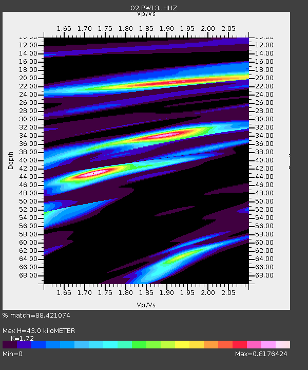
| Estimated Moho Depth: |
43.0 km |
| Estimated Crust Vp/Vs: |
1.72 |
| Assumed Crust Vp: |
6.483 km/s |
| Estimated Crust Vs: |
3.769 km/s |
| Estimated Crust Poisson's Ratio: |
0.24 |
|
| Radial Match: |
88.421074 % |
| Radial Bump: |
240 |
| Transverse Match: |
62.055122 % |
| Transverse Bump: |
323 |
| SOD ConfigId: |
24334971 |
| Insert Time: |
2021-04-03 09:35:49.560 +0000 |
| GWidth: |
2.5 |
| Max Bumps: |
400 |
| Tol: |
0.001 |
|

Signal To Noise
| Channel | StoN | STA | LTA |
| O2:PW13: :HHZ:20210320T09:21:58.700021Z | 5.9996324 | 2.080641E-6 | 3.4679476E-7 |
| O2:PW13: :HHN:20210320T09:21:58.700021Z | 1.4853946 | 7.6429853E-7 | 5.145424E-7 |
| O2:PW13: :HHE:20210320T09:21:58.700021Z | 1.7454667 | 8.413473E-7 | 4.820185E-7 |
| Arrivals |
| Ps | 4.9 SECOND |
| PpPs | 18 SECOND |
| PsPs/PpSs | 23 SECOND |


