You are here: Home > Network List > O2 - Oklahoma Consolidated Temporary Seismic Networks Stations List
> Station SC14 Walters, Oklahoma, USA > Earthquake Result Viewer
SC14 Walters, Oklahoma, USA - Earthquake Result Viewer
| Earthquake location: |
Near East Coast Of Honshu, Japan |
| Earthquake latitude/longitude: |
38.5/141.6 |
| Earthquake time(UTC): |
2021/03/20 (079) 09:09:45 GMT |
| Earthquake Depth: |
54 km |
| Earthquake Magnitude: |
7.0 Mww |
| Earthquake Catalog/Contributor: |
NEIC PDE/us |
|
| Network: |
O2 Oklahoma Consolidated Temporary Seismic Networks |
| Station: |
SC14 Walters, Oklahoma, USA |
| Lat/Lon: |
34.45 N/98.24 W |
| Elevation: |
339 m |
|
| Distance: |
88.7 deg |
| Az: |
45.624 deg |
| Baz: |
317.242 deg |
| Ray Param: |
0.04231846 |
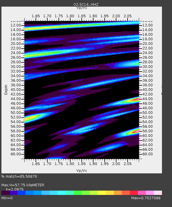
| Estimated Moho Depth: |
57.75 km |
| Estimated Crust Vp/Vs: |
2.10 |
| Assumed Crust Vp: |
6.315 km/s |
| Estimated Crust Vs: |
3.011 km/s |
| Estimated Crust Poisson's Ratio: |
0.35 |
|
| Radial Match: |
85.58678 % |
| Radial Bump: |
400 |
| Transverse Match: |
79.820694 % |
| Transverse Bump: |
400 |
| SOD ConfigId: |
24334971 |
| Insert Time: |
2021-04-03 09:36:10.590 +0000 |
| GWidth: |
2.5 |
| Max Bumps: |
400 |
| Tol: |
0.001 |
|

Signal To Noise
| Channel | StoN | STA | LTA |
| O2:SC14: :HHZ:20210320T09:22:01.524972Z | 5.574055 | 1.9320264E-6 | 3.4661056E-7 |
| O2:SC14: :HHN:20210320T09:22:01.524972Z | 1.442964 | 8.732028E-7 | 6.0514526E-7 |
| O2:SC14: :HHE:20210320T09:22:01.524972Z | 1.0483328 | 4.2242385E-7 | 4.0294825E-7 |
| Arrivals |
| Ps | 10 SECOND |
| PpPs | 28 SECOND |
| PsPs/PpSs | 38 SECOND |


