You are here: Home > Network List > O2 - Oklahoma Consolidated Temporary Seismic Networks Stations List
> Station SC16 Oakwood, Oklahoma, USA > Earthquake Result Viewer
SC16 Oakwood, Oklahoma, USA - Earthquake Result Viewer
| Earthquake location: |
Near East Coast Of Honshu, Japan |
| Earthquake latitude/longitude: |
38.5/141.6 |
| Earthquake time(UTC): |
2021/03/20 (079) 09:09:45 GMT |
| Earthquake Depth: |
54 km |
| Earthquake Magnitude: |
7.0 Mww |
| Earthquake Catalog/Contributor: |
NEIC PDE/us |
|
| Network: |
O2 Oklahoma Consolidated Temporary Seismic Networks |
| Station: |
SC16 Oakwood, Oklahoma, USA |
| Lat/Lon: |
35.97 N/98.82 W |
| Elevation: |
500 m |
|
| Distance: |
87.2 deg |
| Az: |
44.931 deg |
| Baz: |
316.889 deg |
| Ray Param: |
0.043372866 |
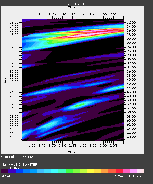
| Estimated Moho Depth: |
18.0 km |
| Estimated Crust Vp/Vs: |
1.89 |
| Assumed Crust Vp: |
6.315 km/s |
| Estimated Crust Vs: |
3.333 km/s |
| Estimated Crust Poisson's Ratio: |
0.31 |
|
| Radial Match: |
82.64882 % |
| Radial Bump: |
385 |
| Transverse Match: |
73.55473 % |
| Transverse Bump: |
400 |
| SOD ConfigId: |
24334971 |
| Insert Time: |
2021-04-03 09:36:13.125 +0000 |
| GWidth: |
2.5 |
| Max Bumps: |
400 |
| Tol: |
0.001 |
|

Signal To Noise
| Channel | StoN | STA | LTA |
| O2:SC16: :HHZ:20210320T09:21:54.719979Z | 2.8288624 | 2.2054855E-6 | 7.796369E-7 |
| O2:SC16: :HHN:20210320T09:21:54.719979Z | 1.2230812 | 7.045795E-7 | 5.760693E-7 |
| O2:SC16: :HHE:20210320T09:21:54.719979Z | 1.4324068 | 5.403448E-7 | 3.7722856E-7 |
| Arrivals |
| Ps | 2.6 SECOND |
| PpPs | 8.1 SECOND |
| PsPs/PpSs | 11 SECOND |


