You are here: Home > Network List > UU - University of Utah Regional Network Stations List
> Station FOR2 Blundell East, UT, USA > Earthquake Result Viewer
FOR2 Blundell East, UT, USA - Earthquake Result Viewer
| Earthquake location: |
Tonga Islands |
| Earthquake latitude/longitude: |
-15.4/-173.2 |
| Earthquake time(UTC): |
2017/11/04 (308) 09:00:19 GMT |
| Earthquake Depth: |
10 km |
| Earthquake Magnitude: |
6.8 Mww |
| Earthquake Catalog/Contributor: |
NEIC PDE/us |
|
| Network: |
UU University of Utah Regional Network |
| Station: |
FOR2 Blundell East, UT, USA |
| Lat/Lon: |
38.49 N/112.87 W |
| Elevation: |
1760 m |
|
| Distance: |
77.8 deg |
| Az: |
44.242 deg |
| Baz: |
239.069 deg |
| Ray Param: |
0.050078932 |
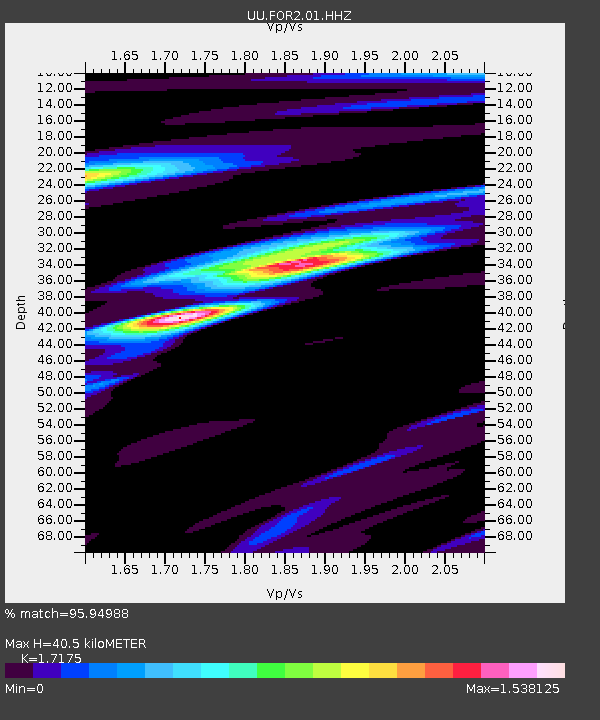
| Estimated Moho Depth: |
40.5 km |
| Estimated Crust Vp/Vs: |
1.72 |
| Assumed Crust Vp: |
6.276 km/s |
| Estimated Crust Vs: |
3.654 km/s |
| Estimated Crust Poisson's Ratio: |
0.24 |
|
| Radial Match: |
95.94988 % |
| Radial Bump: |
353 |
| Transverse Match: |
85.78803 % |
| Transverse Bump: |
338 |
| SOD ConfigId: |
2429771 |
| Insert Time: |
2017-11-18 09:10:13.435 +0000 |
| GWidth: |
2.5 |
| Max Bumps: |
400 |
| Tol: |
0.001 |
|

Signal To Noise
| Channel | StoN | STA | LTA |
| UU:FOR2:01:HHZ:20171104T09:11:45.940022Z | 22.766373 | 9.8751904E-8 | 4.3376214E-9 |
| UU:FOR2:01:HHN:20171104T09:11:45.940022Z | 1.3802329 | 1.5655784E-8 | 1.1342857E-8 |
| UU:FOR2:01:HHE:20171104T09:11:45.940022Z | 4.8163347 | 7.808055E-8 | 1.6211612E-8 |
| Arrivals |
| Ps | 4.8 SECOND |
| PpPs | 17 SECOND |
| PsPs/PpSs | 22 SECOND |


