You are here: Home > Network List > OK - Oklahoma Seismic Network Stations List
> Station FNO Franklin, Norman, OK > Earthquake Result Viewer
FNO Franklin, Norman, OK - Earthquake Result Viewer
| Earthquake location: |
Near East Coast Of Honshu, Japan |
| Earthquake latitude/longitude: |
38.5/141.6 |
| Earthquake time(UTC): |
2021/03/20 (079) 09:09:45 GMT |
| Earthquake Depth: |
54 km |
| Earthquake Magnitude: |
7.0 Mww |
| Earthquake Catalog/Contributor: |
NEIC PDE/us |
|
| Network: |
OK Oklahoma Seismic Network |
| Station: |
FNO Franklin, Norman, OK |
| Lat/Lon: |
35.26 N/97.40 W |
| Elevation: |
360 m |
|
| Distance: |
88.5 deg |
| Az: |
44.57 deg |
| Baz: |
317.696 deg |
| Ray Param: |
0.042410955 |
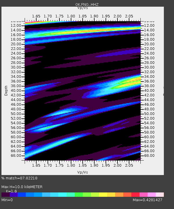
| Estimated Moho Depth: |
10.0 km |
| Estimated Crust Vp/Vs: |
1.60 |
| Assumed Crust Vp: |
6.426 km/s |
| Estimated Crust Vs: |
4.016 km/s |
| Estimated Crust Poisson's Ratio: |
0.18 |
|
| Radial Match: |
87.82218 % |
| Radial Bump: |
304 |
| Transverse Match: |
87.6926 % |
| Transverse Bump: |
289 |
| SOD ConfigId: |
24334971 |
| Insert Time: |
2021-04-03 09:36:56.951 +0000 |
| GWidth: |
2.5 |
| Max Bumps: |
400 |
| Tol: |
0.001 |
|

Signal To Noise
| Channel | StoN | STA | LTA |
| OK:FNO: :HHZ:20210320T09:22:00.945016Z | 8.646098 | 2.7881827E-6 | 3.224787E-7 |
| OK:FNO: :HHN:20210320T09:22:00.945016Z | 0.7600472 | 8.22245E-9 | 1.0818342E-8 |
| OK:FNO: :HHE:20210320T09:22:00.945016Z | 1.3302592 | 7.798125E-7 | 5.8621094E-7 |
| Arrivals |
| Ps | 1.0 SECOND |
| PpPs | 4.0 SECOND |
| PsPs/PpSs | 4.9 SECOND |


