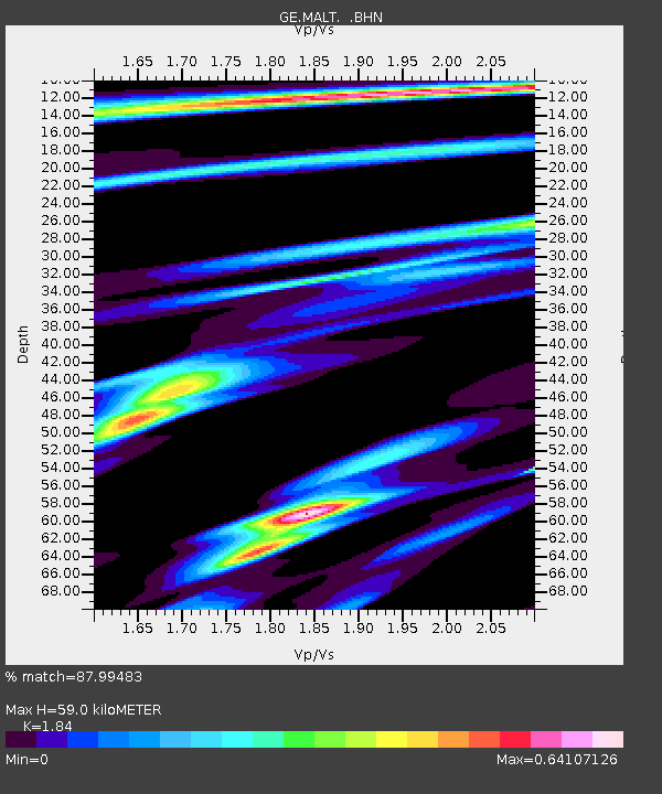
MALT GEOFON/MedNet Station Malatya, Turkey - Earthquake Result Viewer

Earthquake location: Near S. Coast Of Honshu, Japan
Earthquake latitude/longitude: 34.1/139.2
Earthquake time(UTC): 2000/08/18 (231) 01:52:20 GMT
Earthquake Depth: 10 km
Earthquake Magnitude: 5.6 MB, 5.5 MS, 5.8 MW, 5.7 MW
Earthquake Catalog/Contributor: WHDF/NEIC
Network: GE GEOFON
Station: MALT GEOFON/MedNet Station Malatya, Turkey
Lat/Lon: 38.31 N/38.43 E
Elevation: 1120 m
Distance: 77.1 deg
Az: 307.551 deg
Baz: 56.724 deg
Ray Param: 0.050542045
Estimated Moho Depth: 59.0 km
Estimated Crust Vp/Vs: 1.84
Assumed Crust Vp: 6.35 km/s
Estimated Crust Vs: 3.451 km/s
Estimated Crust Poisson's Ratio: 0.29
Radial Match: 87.99483 %
Radial Bump: 357
Transverse Match: 81.64123 %
Transverse Bump: 400
SOD ConfigId: 3753
Insert Time: 2010-03-09 06:44:34.941 +0000
GWidth: 2.5
Max Bumps: 400
Tol: 0.001

Signal To Noise

ChannelStoNSTALTA
GE:MALT: :BHN:20000818T02:03:43.034001Z1.60685913.9848203E-82.4798814E-8
GE:MALT: :BHE:20000818T02:03:43.034001Z0.749746741.9583744E-82.6120478E-8
GE:MALT: :BHZ:20000818T02:03:43.034001Z1.83201667.7617834E-84.2367432E-8
Arrivals
Ps8.0 SECOND
PpPs26 SECOND
PsPs/PpSs34 SECOND