You are here: Home > Network List > UU - University of Utah Regional Network Stations List
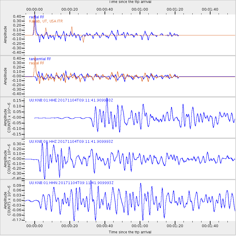
> Station KNB Kanab, UT, USA > Earthquake Result Viewer
KNB Kanab, UT, USA - Earthquake Result Viewer
| Earthquake location: |
Tonga Islands |
| Earthquake latitude/longitude: |
-15.4/-173.2 |
| Earthquake time(UTC): |
2017/11/04 (308) 09:00:19 GMT |
| Earthquake Depth: |
10 km |
| Earthquake Magnitude: |
6.8 Mww |
| Earthquake Catalog/Contributor: |
NEIC PDE/us |
|
| Network: |
UU University of Utah Regional Network |
| Station: |
KNB Kanab, UT, USA |
| Lat/Lon: |
37.02 N/112.82 W |
| Elevation: |
1715 m |
|
| Distance: |
77.1 deg |
| Az: |
45.563 deg |
| Baz: |
239.387 deg |
| Ray Param: |
0.050567057 |
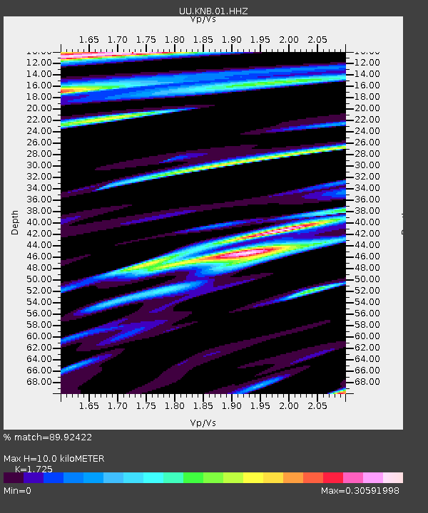
| Estimated Moho Depth: |
10.0 km |
| Estimated Crust Vp/Vs: |
1.73 |
| Assumed Crust Vp: |
6.194 km/s |
| Estimated Crust Vs: |
3.591 km/s |
| Estimated Crust Poisson's Ratio: |
0.25 |
|
| Radial Match: |
89.92422 % |
| Radial Bump: |
254 |
| Transverse Match: |
83.94652 % |
| Transverse Bump: |
335 |
| SOD ConfigId: |
2429771 |
| Insert Time: |
2017-11-18 09:10:25.338 +0000 |
| GWidth: |
2.5 |
| Max Bumps: |
400 |
| Tol: |
0.001 |
|
Signal To Noise
| Channel | StoN | STA | LTA |
| UU:KNB:01:HHZ:20171104T09:11:41.909993Z | 31.515871 | 1.3423015E-7 | 4.259129E-9 |
| UU:KNB:01:HHN:20171104T09:11:41.909993Z | 5.5521007 | 1.8294363E-8 | 3.2950347E-9 |
| UU:KNB:01:HHE:20171104T09:11:41.909993Z | 11.665776 | 3.8805528E-8 | 3.3264422E-9 |
| Arrivals |
| Ps | 1.2 SECOND |
| PpPs | 4.3 SECOND |
| PsPs/PpSs | 5.5 SECOND |


