You are here: Home > Network List > RV - Regional Alberta Seismic Observatory for Earthquake Studies Network Stations List
> Station WTMTA White Mountain Lookout Tower, AB > Earthquake Result Viewer
WTMTA White Mountain Lookout Tower, AB - Earthquake Result Viewer
| Earthquake location: |
Near East Coast Of Honshu, Japan |
| Earthquake latitude/longitude: |
38.5/141.6 |
| Earthquake time(UTC): |
2021/03/20 (079) 09:09:45 GMT |
| Earthquake Depth: |
54 km |
| Earthquake Magnitude: |
7.0 Mww |
| Earthquake Catalog/Contributor: |
NEIC PDE/us |
|
| Network: |
RV Regional Alberta Seismic Observatory for Earthquake Studies Network |
| Station: |
WTMTA White Mountain Lookout Tower, AB |
| Lat/Lon: |
55.69 N/119.24 W |
| Elevation: |
1030 m |
|
| Distance: |
63.9 deg |
| Az: |
38.498 deg |
| Baz: |
300.351 deg |
| Ray Param: |
0.059159912 |
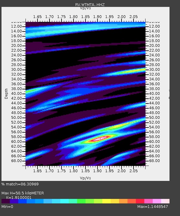
| Estimated Moho Depth: |
58.5 km |
| Estimated Crust Vp/Vs: |
1.91 |
| Assumed Crust Vp: |
6.161 km/s |
| Estimated Crust Vs: |
3.226 km/s |
| Estimated Crust Poisson's Ratio: |
0.31 |
|
| Radial Match: |
86.30969 % |
| Radial Bump: |
400 |
| Transverse Match: |
72.6981 % |
| Transverse Bump: |
400 |
| SOD ConfigId: |
24334971 |
| Insert Time: |
2021-04-03 09:39:23.777 +0000 |
| GWidth: |
2.5 |
| Max Bumps: |
400 |
| Tol: |
0.001 |
|

Signal To Noise
| Channel | StoN | STA | LTA |
| RV:WTMTA: :HHZ:20210320T09:19:41.680001Z | 6.909846 | 3.2618234E-6 | 4.7205444E-7 |
| RV:WTMTA: :HHN:20210320T09:19:41.680001Z | 0.6175101 | 9.4128615E-7 | 1.5243252E-6 |
| RV:WTMTA: :HHE:20210320T09:19:41.680001Z | 1.0884088 | 1.0504641E-6 | 9.651375E-7 |
| Arrivals |
| Ps | 9.0 SECOND |
| PpPs | 27 SECOND |
| PsPs/PpSs | 36 SECOND |


