You are here: Home > Network List > RV - Regional Alberta Seismic Observatory for Earthquake Studies Network Stations List
> Station YELLA Yellowhead Lookout Tower, AB > Earthquake Result Viewer
YELLA Yellowhead Lookout Tower, AB - Earthquake Result Viewer
| Earthquake location: |
Near East Coast Of Honshu, Japan |
| Earthquake latitude/longitude: |
38.5/141.6 |
| Earthquake time(UTC): |
2021/03/20 (079) 09:09:45 GMT |
| Earthquake Depth: |
54 km |
| Earthquake Magnitude: |
7.0 Mww |
| Earthquake Catalog/Contributor: |
NEIC PDE/us |
|
| Network: |
RV Regional Alberta Seismic Observatory for Earthquake Studies Network |
| Station: |
YELLA Yellowhead Lookout Tower, AB |
| Lat/Lon: |
53.24 N/117.14 W |
| Elevation: |
1478 m |
|
| Distance: |
66.2 deg |
| Az: |
40.106 deg |
| Baz: |
302.733 deg |
| Ray Param: |
0.05764018 |
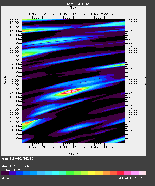
| Estimated Moho Depth: |
45.0 km |
| Estimated Crust Vp/Vs: |
1.84 |
| Assumed Crust Vp: |
6.142 km/s |
| Estimated Crust Vs: |
3.343 km/s |
| Estimated Crust Poisson's Ratio: |
0.29 |
|
| Radial Match: |
92.56132 % |
| Radial Bump: |
400 |
| Transverse Match: |
85.35304 % |
| Transverse Bump: |
353 |
| SOD ConfigId: |
24334971 |
| Insert Time: |
2021-04-03 09:39:23.957 +0000 |
| GWidth: |
2.5 |
| Max Bumps: |
400 |
| Tol: |
0.001 |
|

Signal To Noise
| Channel | StoN | STA | LTA |
| RV:YELLA: :HHZ:20210320T09:19:56.770028Z | 5.4316053 | 3.2248101E-6 | 5.937122E-7 |
| RV:YELLA: :HHN:20210320T09:19:56.770028Z | 2.2375426 | 1.0758833E-6 | 4.8083257E-7 |
| RV:YELLA: :HHE:20210320T09:19:56.770028Z | 2.1206944 | 1.1716534E-6 | 5.524857E-7 |
| Arrivals |
| Ps | 6.4 SECOND |
| PpPs | 20 SECOND |
| PsPs/PpSs | 26 SECOND |


