You are here: Home > Network List > S1 - Australian Seismometers in Schools Stations List
> Station AUMBR Murray Bridge High School > Earthquake Result Viewer
AUMBR Murray Bridge High School - Earthquake Result Viewer
| Earthquake location: |
Near East Coast Of Honshu, Japan |
| Earthquake latitude/longitude: |
38.5/141.6 |
| Earthquake time(UTC): |
2021/03/20 (079) 09:09:45 GMT |
| Earthquake Depth: |
54 km |
| Earthquake Magnitude: |
7.0 Mww |
| Earthquake Catalog/Contributor: |
NEIC PDE/us |
|
| Network: |
S1 Australian Seismometers in Schools |
| Station: |
AUMBR Murray Bridge High School |
| Lat/Lon: |
35.13 S/139.29 E |
| Elevation: |
50 m |
|
| Distance: |
73.3 deg |
| Az: |
181.986 deg |
| Baz: |
1.902 deg |
| Ray Param: |
0.053009935 |
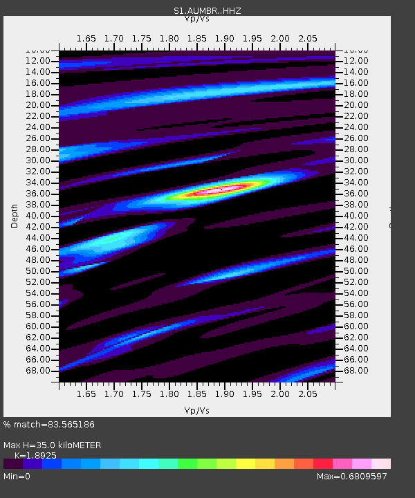
| Estimated Moho Depth: |
35.0 km |
| Estimated Crust Vp/Vs: |
1.89 |
| Assumed Crust Vp: |
6.576 km/s |
| Estimated Crust Vs: |
3.475 km/s |
| Estimated Crust Poisson's Ratio: |
0.31 |
|
| Radial Match: |
83.565186 % |
| Radial Bump: |
400 |
| Transverse Match: |
60.090786 % |
| Transverse Bump: |
400 |
| SOD ConfigId: |
24334971 |
| Insert Time: |
2021-04-03 09:39:44.268 +0000 |
| GWidth: |
2.5 |
| Max Bumps: |
400 |
| Tol: |
0.001 |
|

Signal To Noise
| Channel | StoN | STA | LTA |
| S1:AUMBR: :HHZ:20210320T09:20:39.96003Z | 3.8413312 | 2.1831322E-6 | 5.68327E-7 |
| S1:AUMBR: :HHN:20210320T09:20:39.96003Z | 1.473671 | 1.1271364E-6 | 7.6484946E-7 |
| S1:AUMBR: :HHE:20210320T09:20:39.96003Z | 1.1237388 | 4.6561007E-7 | 4.1434015E-7 |
| Arrivals |
| Ps | 4.9 SECOND |
| PpPs | 15 SECOND |
| PsPs/PpSs | 20 SECOND |


