You are here: Home > Network List > TA - USArray Transportable Network (new EarthScope stations) Stations List
> Station G30M t˙h Zraii Njik, YT, CAN > Earthquake Result Viewer
G30M t˙h Zraii Njik, YT, CAN - Earthquake Result Viewer
| Earthquake location: |
Near East Coast Of Honshu, Japan |
| Earthquake latitude/longitude: |
38.5/141.6 |
| Earthquake time(UTC): |
2021/03/20 (079) 09:09:45 GMT |
| Earthquake Depth: |
54 km |
| Earthquake Magnitude: |
7.0 Mww |
| Earthquake Catalog/Contributor: |
NEIC PDE/us |
|
| Network: |
TA USArray Transportable Network (new EarthScope stations) |
| Station: |
G30M t˙h Zraii Njik, YT, CAN |
| Lat/Lon: |
66.98 N/136.22 W |
| Elevation: |
739 m |
|
| Distance: |
52.3 deg |
| Az: |
29.505 deg |
| Baz: |
280.59 deg |
| Ray Param: |
0.06671084 |
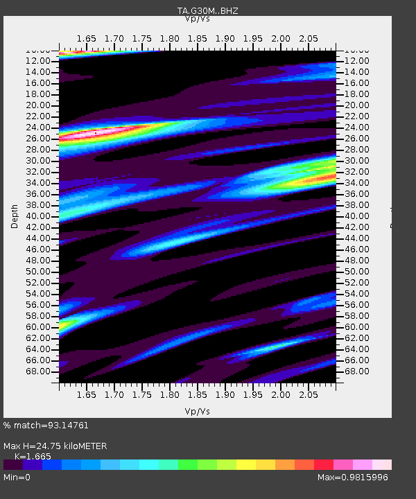
| Estimated Moho Depth: |
24.75 km |
| Estimated Crust Vp/Vs: |
1.66 |
| Assumed Crust Vp: |
6.522 km/s |
| Estimated Crust Vs: |
3.917 km/s |
| Estimated Crust Poisson's Ratio: |
0.22 |
|
| Radial Match: |
93.14761 % |
| Radial Bump: |
396 |
| Transverse Match: |
86.750626 % |
| Transverse Bump: |
400 |
| SOD ConfigId: |
24334971 |
| Insert Time: |
2021-04-03 09:40:56.887 +0000 |
| GWidth: |
2.5 |
| Max Bumps: |
400 |
| Tol: |
0.001 |
|

Signal To Noise
| Channel | StoN | STA | LTA |
| TA:G30M: :BHZ:20210320T09:18:20.700021Z | 18.378494 | 3.7182376E-6 | 2.023146E-7 |
| TA:G30M: :BHN:20210320T09:18:20.700021Z | 3.2148304 | 7.2322206E-7 | 2.249643E-7 |
| TA:G30M: :BHE:20210320T09:18:20.700021Z | 6.549274 | 1.6965695E-6 | 2.5904697E-7 |
| Arrivals |
| Ps | 2.7 SECOND |
| PpPs | 9.5 SECOND |
| PsPs/PpSs | 12 SECOND |


