You are here: Home > Network List > TA - USArray Transportable Network (new EarthScope stations) Stations List
> Station H27K Steamboat Mountain, AK, USA > Earthquake Result Viewer
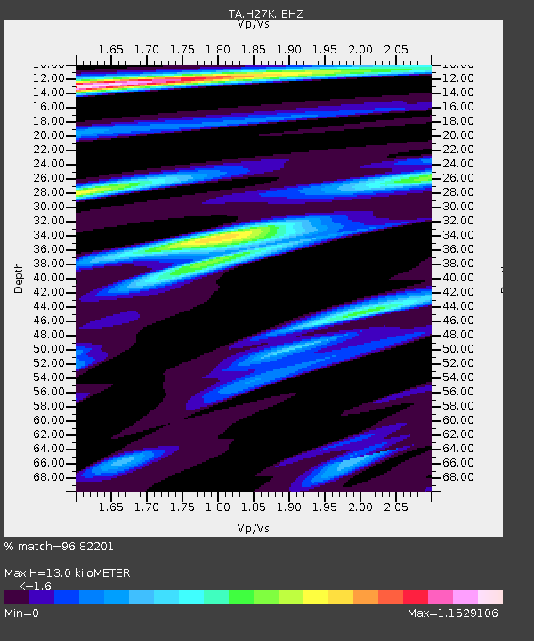
H27K Steamboat Mountain, AK, USA - Earthquake Result Viewer
| Earthquake location: |
Near East Coast Of Honshu, Japan |
| Earthquake latitude/longitude: |
38.5/141.6 |
| Earthquake time(UTC): |
2021/03/20 (079) 09:09:45 GMT |
| Earthquake Depth: |
54 km |
| Earthquake Magnitude: |
7.0 Mww |
| Earthquake Catalog/Contributor: |
NEIC PDE/us |
|
| Network: |
TA USArray Transportable Network (new EarthScope stations) |
| Station: |
H27K Steamboat Mountain, AK, USA |
| Lat/Lon: |
66.23 N/141.53 W |
| Elevation: |
786 m |
|
| Distance: |
50.3 deg |
| Az: |
30.864 deg |
| Baz: |
276.575 deg |
| Ray Param: |
0.06800136 |
| Estimated Moho Depth: |
13.0 km |
| Estimated Crust Vp/Vs: |
1.60 |
| Assumed Crust Vp: |
6.577 km/s |
| Estimated Crust Vs: |
4.11 km/s |
| Estimated Crust Poisson's Ratio: |
0.18 |
|
| Radial Match: |
96.82201 % |
| Radial Bump: |
320 |
| Transverse Match: |
85.718544 % |
| Transverse Bump: |
400 |
| SOD ConfigId: |
24334971 |
| Insert Time: |
2021-04-03 09:41:02.174 +0000 |
| GWidth: |
2.5 |
| Max Bumps: |
400 |
| Tol: |
0.001 |
|

Signal To Noise
| Channel | StoN | STA | LTA |
| TA:H27K: :BHZ:20210320T09:18:05.900002Z | 14.098606 | 2.8379955E-6 | 2.0129619E-7 |
| TA:H27K: :BHN:20210320T09:18:05.900002Z | 0.686855 | 2.208496E-7 | 3.215374E-7 |
| TA:H27K: :BHE:20210320T09:18:05.900002Z | 6.6694913 | 1.5037696E-6 | 2.254699E-7 |
| Arrivals |
| Ps | 1.3 SECOND |
| PpPs | 4.8 SECOND |
| PsPs/PpSs | 6.1 SECOND |


