You are here: Home > Network List > TA - USArray Transportable Network (new EarthScope stations) Stations List
> Station I17K Unalakleet, AK, USA > Earthquake Result Viewer
I17K Unalakleet, AK, USA - Earthquake Result Viewer
| Earthquake location: |
Near East Coast Of Honshu, Japan |
| Earthquake latitude/longitude: |
38.5/141.6 |
| Earthquake time(UTC): |
2021/03/20 (079) 09:09:45 GMT |
| Earthquake Depth: |
54 km |
| Earthquake Magnitude: |
7.0 Mww |
| Earthquake Catalog/Contributor: |
NEIC PDE/us |
|
| Network: |
TA USArray Transportable Network (new EarthScope stations) |
| Station: |
I17K Unalakleet, AK, USA |
| Lat/Lon: |
63.89 N/160.70 W |
| Elevation: |
105 m |
|
| Distance: |
42.2 deg |
| Az: |
33.867 deg |
| Baz: |
261.266 deg |
| Ray Param: |
0.07320288 |
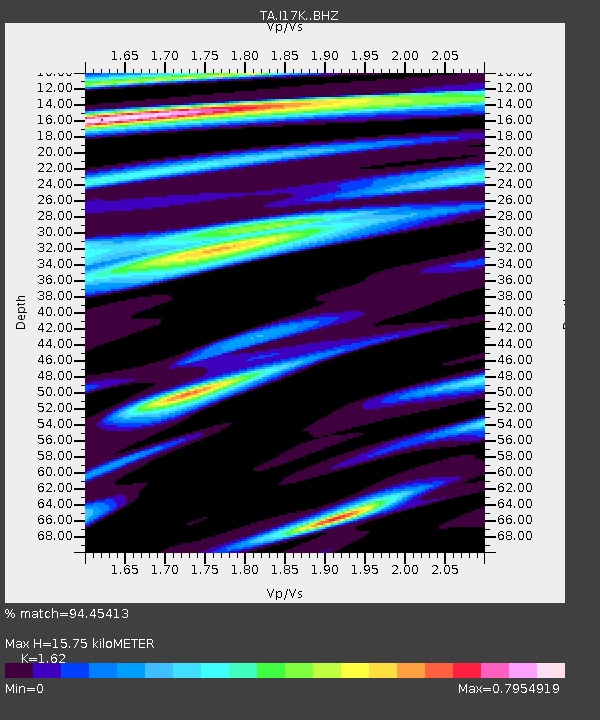
| Estimated Moho Depth: |
15.75 km |
| Estimated Crust Vp/Vs: |
1.62 |
| Assumed Crust Vp: |
6.276 km/s |
| Estimated Crust Vs: |
3.874 km/s |
| Estimated Crust Poisson's Ratio: |
0.19 |
|
| Radial Match: |
94.45413 % |
| Radial Bump: |
391 |
| Transverse Match: |
88.097855 % |
| Transverse Bump: |
400 |
| SOD ConfigId: |
24334971 |
| Insert Time: |
2021-04-03 09:41:07.882 +0000 |
| GWidth: |
2.5 |
| Max Bumps: |
400 |
| Tol: |
0.001 |
|
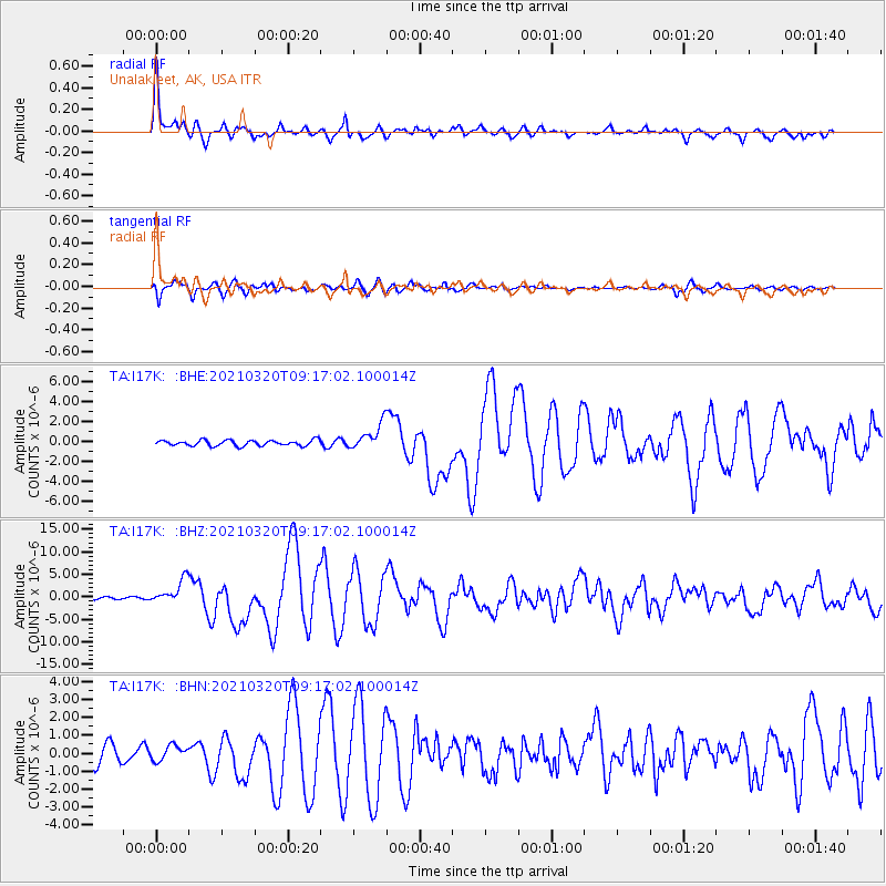
Signal To Noise
| Channel | StoN | STA | LTA |
| TA:I17K: :BHZ:20210320T09:17:02.100014Z | 8.97072 | 2.641243E-6 | 2.9442933E-7 |
| TA:I17K: :BHN:20210320T09:17:02.100014Z | 1.118612 | 4.1495892E-7 | 3.7095876E-7 |
| TA:I17K: :BHE:20210320T09:17:02.100014Z | 4.557311 | 1.2989054E-6 | 2.8501574E-7 |
| Arrivals |
| Ps | 1.7 SECOND |
| PpPs | 6.1 SECOND |
| PsPs/PpSs | 7.8 SECOND |


