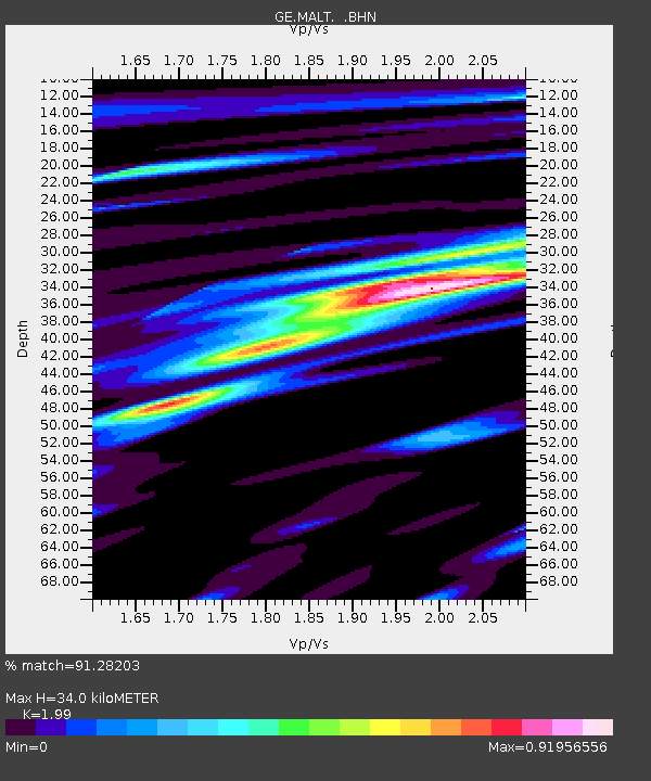
MALT GEOFON/MedNet Station Malatya, Turkey - Earthquake Result Viewer

Earthquake location: Southwest Of Sumatra, Indonesia
Earthquake latitude/longitude: -6.0/102.7
Earthquake time(UTC): 2000/08/24 (237) 11:36:45 GMT
Earthquake Depth: 33 km
Earthquake Magnitude: 5.7 MB, 5.9 MS, 6.0 MW, 5.8 MW
Earthquake Catalog/Contributor: WHDF/NEIC
Network: GE GEOFON
Station: MALT GEOFON/MedNet Station Malatya, Turkey
Lat/Lon: 38.31 N/38.43 E
Elevation: 1120 m
Distance: 74.0 deg
Az: 312.515 deg
Baz: 111.268 deg
Ray Param: 0.05256974
Estimated Moho Depth: 34.0 km
Estimated Crust Vp/Vs: 1.99
Assumed Crust Vp: 6.35 km/s
Estimated Crust Vs: 3.191 km/s
Estimated Crust Poisson's Ratio: 0.33
Radial Match: 91.28203 %
Radial Bump: 400
Transverse Match: 79.702675 %
Transverse Bump: 400
SOD ConfigId: 3744
Insert Time: 2010-03-09 06:44:57.289 +0000
GWidth: 2.5
Max Bumps: 400
Tol: 0.001

Signal To Noise

ChannelStoNSTALTA
GE:MALT: :BHN:20000824T11:47:46.732Z1.38506563.7096672E-82.6783333E-8
GE:MALT: :BHE:20000824T11:47:46.732Z1.39452026.112315E-84.3830955E-8
GE:MALT: :BHZ:20000824T11:47:46.732Z4.61340051.9656052E-74.2606427E-8
Arrivals
Ps5.5 SECOND
PpPs16 SECOND
PsPs/PpSs21 SECOND