You are here: Home > Network List > TA - USArray Transportable Network (new EarthScope stations) Stations List
> Station O17K Koliganek, Bristol Bay, AK, USA > Earthquake Result Viewer
O17K Koliganek, Bristol Bay, AK, USA - Earthquake Result Viewer
| Earthquake location: |
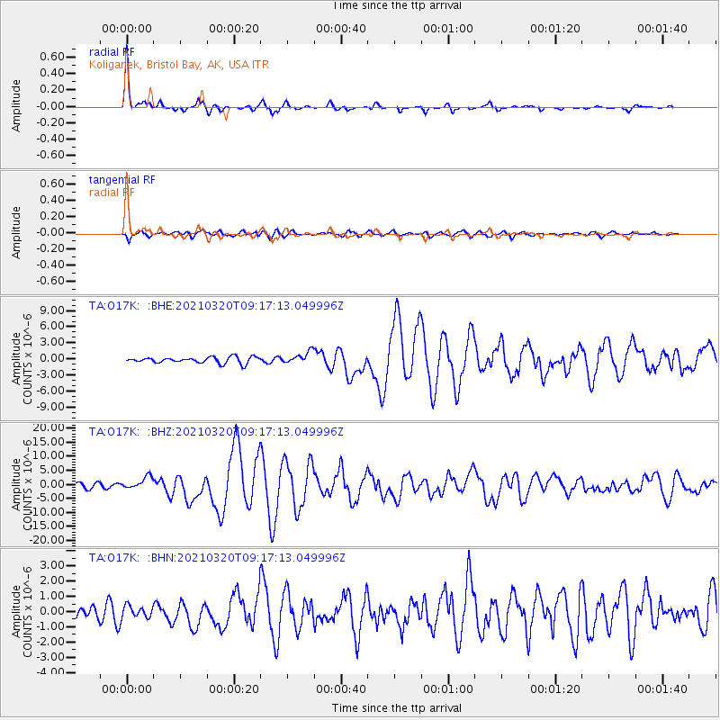
Near East Coast Of Honshu, Japan |
| Earthquake latitude/longitude: |
38.5/141.6 |
| Earthquake time(UTC): |
2021/03/20 (079) 09:09:45 GMT |
| Earthquake Depth: |
54 km |
| Earthquake Magnitude: |
7.0 Mww |
| Earthquake Catalog/Contributor: |
NEIC PDE/us |
|
| Network: |
TA USArray Transportable Network (new EarthScope stations) |
| Station: |
O17K Koliganek, Bristol Bay, AK, USA |
| Lat/Lon: |
59.77 N/157.09 W |
| Elevation: |
156 m |
|
| Distance: |
43.5 deg |
| Az: |
40.129 deg |
| Baz: |
269.031 deg |
| Ray Param: |
0.072348386 |
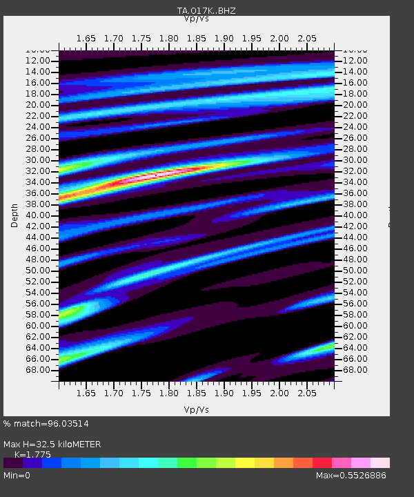
| Estimated Moho Depth: |
32.5 km |
| Estimated Crust Vp/Vs: |
1.77 |
| Assumed Crust Vp: |
6.276 km/s |
| Estimated Crust Vs: |
3.536 km/s |
| Estimated Crust Poisson's Ratio: |
0.27 |
|
| Radial Match: |
96.03514 % |
| Radial Bump: |
315 |
| Transverse Match: |
76.96394 % |
| Transverse Bump: |
400 |
| SOD ConfigId: |
24334971 |
| Insert Time: |
2021-04-03 09:41:48.305 +0000 |
| GWidth: |
2.5 |
| Max Bumps: |
400 |
| Tol: |
0.001 |
|
Signal To Noise
| Channel | StoN | STA | LTA |
| TA:O17K: :BHZ:20210320T09:17:13.049996Z | 2.7734702 | 2.216283E-6 | 7.9910114E-7 |
| TA:O17K: :BHN:20210320T09:17:13.049996Z | 0.9760572 | 3.723003E-7 | 3.8143287E-7 |
| TA:O17K: :BHE:20210320T09:17:13.049996Z | 1.9103681 | 1.0842991E-6 | 5.6758654E-7 |
| Arrivals |
| Ps | 4.3 SECOND |
| PpPs | 14 SECOND |
| PsPs/PpSs | 18 SECOND |


