You are here: Home > Network List > TA - USArray Transportable Network (new EarthScope stations) Stations List
> Station O29M Mount Kennedy, YT, CAN > Earthquake Result Viewer
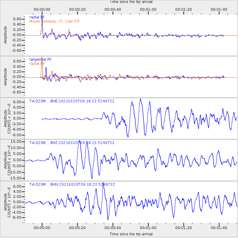
O29M Mount Kennedy, YT, CAN - Earthquake Result Viewer

| Earthquake location: |
Near East Coast Of Honshu, Japan |
| Earthquake latitude/longitude: |
38.5/141.6 |
| Earthquake time(UTC): |
2021/03/20 (079) 09:09:45 GMT |
| Earthquake Depth: |
54 km |
| Earthquake Magnitude: |
7.0 Mww |
| Earthquake Catalog/Contributor: |
NEIC PDE/us |
|
| Network: |
TA USArray Transportable Network (new EarthScope stations) |
| Station: |
O29M Mount Kennedy, YT, CAN |
| Lat/Lon: |
60.30 N/138.58 W |
| Elevation: |
1423 m |
|
| Distance: |
52.7 deg |
| Az: |
38.051 deg |
| Baz: |
283.691 deg |
| Ray Param: |
0.066479914 |
| Estimated Moho Depth: |
36.25 km |
| Estimated Crust Vp/Vs: |
1.98 |
| Assumed Crust Vp: |
6.566 km/s |
| Estimated Crust Vs: |
3.316 km/s |
| Estimated Crust Poisson's Ratio: |
0.33 |
|
| Radial Match: |
97.07228 % |
| Radial Bump: |
400 |
| Transverse Match: |
93.97323 % |
| Transverse Bump: |
358 |
| SOD ConfigId: |
24334971 |
| Insert Time: |
2021-04-03 09:41:50.876 +0000 |
| GWidth: |
2.5 |
| Max Bumps: |
400 |
| Tol: |
0.001 |
|
Signal To Noise
| Channel | StoN | STA | LTA |
| TA:O29M: :BHZ:20210320T09:18:23.524972Z | 8.302473 | 1.8536729E-6 | 2.2326756E-7 |
| TA:O29M: :BHN:20210320T09:18:23.524972Z | 1.4670577 | 3.6316652E-7 | 2.4754752E-7 |
| TA:O29M: :BHE:20210320T09:18:23.524972Z | 5.539924 | 9.644426E-7 | 1.7408948E-7 |
| Arrivals |
| Ps | 5.7 SECOND |
| PpPs | 16 SECOND |
| PsPs/PpSs | 21 SECOND |


