You are here: Home > Network List > UU - University of Utah Regional Network Stations List
> Station TCU Toone Canyon, UT, USA > Earthquake Result Viewer
TCU Toone Canyon, UT, USA - Earthquake Result Viewer
| Earthquake location: |
Tonga Islands |
| Earthquake latitude/longitude: |
-15.4/-173.2 |
| Earthquake time(UTC): |
2017/11/04 (308) 09:00:19 GMT |
| Earthquake Depth: |
10 km |
| Earthquake Magnitude: |
6.8 Mww |
| Earthquake Catalog/Contributor: |
NEIC PDE/us |
|
| Network: |
UU University of Utah Regional Network |
| Station: |
TCU Toone Canyon, UT, USA |
| Lat/Lon: |
41.12 N/111.41 W |
| Elevation: |
2269 m |
|
| Distance: |
80.1 deg |
| Az: |
42.532 deg |
| Baz: |
239.675 deg |
| Ray Param: |
0.048506815 |
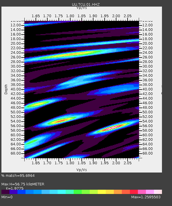
| Estimated Moho Depth: |
56.75 km |
| Estimated Crust Vp/Vs: |
1.98 |
| Assumed Crust Vp: |
6.155 km/s |
| Estimated Crust Vs: |
3.112 km/s |
| Estimated Crust Poisson's Ratio: |
0.33 |
|
| Radial Match: |
95.6964 % |
| Radial Bump: |
335 |
| Transverse Match: |
92.7811 % |
| Transverse Bump: |
362 |
| SOD ConfigId: |
2429771 |
| Insert Time: |
2017-11-18 09:10:57.592 +0000 |
| GWidth: |
2.5 |
| Max Bumps: |
400 |
| Tol: |
0.001 |
|

Signal To Noise
| Channel | StoN | STA | LTA |
| UU:TCU:01:HHZ:20171104T09:11:58.529988Z | 45.108704 | 1.7307151E-7 | 3.836765E-9 |
| UU:TCU:01:HHN:20171104T09:11:58.529988Z | 5.708208 | 2.3438727E-8 | 4.1061443E-9 |
| UU:TCU:01:HHE:20171104T09:11:58.529988Z | 12.617211 | 7.341469E-8 | 5.8186145E-9 |
| Arrivals |
| Ps | 9.2 SECOND |
| PpPs | 27 SECOND |
| PsPs/PpSs | 36 SECOND |


