You are here: Home > Network List > TX - Texas Seismological Network Stations List
> Station PB17 Fort Stockton > Earthquake Result Viewer
PB17 Fort Stockton - Earthquake Result Viewer
| Earthquake location: |
Near East Coast Of Honshu, Japan |
| Earthquake latitude/longitude: |
38.5/141.6 |
| Earthquake time(UTC): |
2021/03/20 (079) 09:09:45 GMT |
| Earthquake Depth: |
54 km |
| Earthquake Magnitude: |
7.0 Mww |
| Earthquake Catalog/Contributor: |
NEIC PDE/us |
|
| Network: |
TX Texas Seismological Network |
| Station: |
PB17 Fort Stockton |
| Lat/Lon: |
31.00 N/103.15 W |
| Elevation: |
734 m |
|
| Distance: |
88.3 deg |
| Az: |
50.994 deg |
| Baz: |
314.742 deg |
| Ray Param: |
0.04261581 |
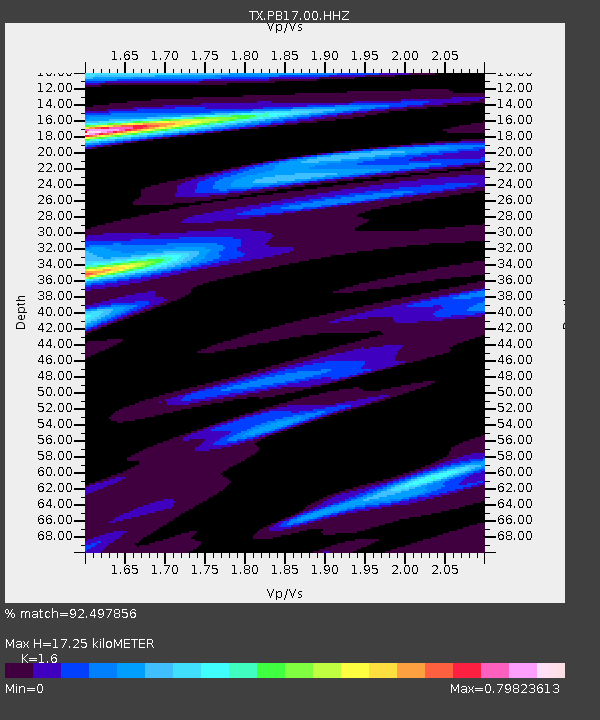
| Estimated Moho Depth: |
17.25 km |
| Estimated Crust Vp/Vs: |
1.60 |
| Assumed Crust Vp: |
6.121 km/s |
| Estimated Crust Vs: |
3.825 km/s |
| Estimated Crust Poisson's Ratio: |
0.18 |
|
| Radial Match: |
92.497856 % |
| Radial Bump: |
400 |
| Transverse Match: |
78.54727 % |
| Transverse Bump: |
400 |
| SOD ConfigId: |
24334971 |
| Insert Time: |
2021-04-03 09:43:55.574 +0000 |
| GWidth: |
2.5 |
| Max Bumps: |
400 |
| Tol: |
0.001 |
|

Signal To Noise
| Channel | StoN | STA | LTA |
| TX:PB17:00:HHZ:20210320T09:21:59.649972Z | 2.2249422 | 9.625188E-7 | 4.3260397E-7 |
| TX:PB17:00:HH1:20210320T09:21:59.649972Z | 0.7001756 | 2.965379E-7 | 4.2351937E-7 |
| TX:PB17:00:HH2:20210320T09:21:59.649972Z | 1.0969194 | 3.2217832E-7 | 2.9371193E-7 |
| Arrivals |
| Ps | 1.7 SECOND |
| PpPs | 7.2 SECOND |
| PsPs/PpSs | 8.9 SECOND |


