You are here: Home > Network List > TX - Texas Seismological Network Stations List
> Station PB32 CR 111 > Earthquake Result Viewer
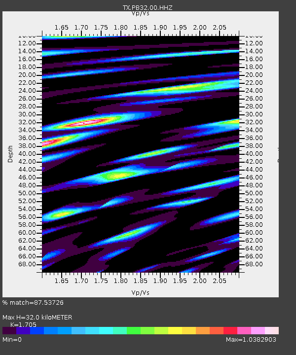
PB32 CR 111 - Earthquake Result Viewer
| Earthquake location: |
Near East Coast Of Honshu, Japan |
| Earthquake latitude/longitude: |
38.5/141.6 |
| Earthquake time(UTC): |
2021/03/20 (079) 09:09:45 GMT |
| Earthquake Depth: |
54 km |
| Earthquake Magnitude: |
7.0 Mww |
| Earthquake Catalog/Contributor: |
NEIC PDE/us |
|
| Network: |
TX Texas Seismological Network |
| Station: |
PB32 CR 111 |
| Lat/Lon: |
31.10 N/103.37 W |
| Elevation: |
861 m |
|
| Distance: |
88.1 deg |
| Az: |
51.052 deg |
| Baz: |
314.63 deg |
| Ray Param: |
0.042772163 |
| Estimated Moho Depth: |
32.0 km |
| Estimated Crust Vp/Vs: |
1.71 |
| Assumed Crust Vp: |
6.121 km/s |
| Estimated Crust Vs: |
3.59 km/s |
| Estimated Crust Poisson's Ratio: |
0.24 |
|
| Radial Match: |
87.53726 % |
| Radial Bump: |
400 |
| Transverse Match: |
74.92068 % |
| Transverse Bump: |
400 |
| SOD ConfigId: |
24334971 |
| Insert Time: |
2021-04-03 09:43:56.906 +0000 |
| GWidth: |
2.5 |
| Max Bumps: |
400 |
| Tol: |
0.001 |
|

Signal To Noise
| Channel | StoN | STA | LTA |
| TX:PB32:00:HHZ:20210320T09:21:58.659981Z | 2.6272898 | 6.162937E-8 | 2.3457392E-8 |
| TX:PB32:00:HH1:20210320T09:21:58.659981Z | 1.6739993 | 8.2407695E-8 | 4.9228035E-8 |
| TX:PB32:00:HH2:20210320T09:21:58.659981Z | 1.8934845 | 6.977334E-8 | 3.6849176E-8 |
| Arrivals |
| Ps | 3.8 SECOND |
| PpPs | 14 SECOND |
| PsPs/PpSs | 18 SECOND |


