You are here: Home > Network List > US - United States National Seismic Network Stations List
> Station ECSD EROS Data Center, Sioux Falls, South Dakota, USA > Earthquake Result Viewer
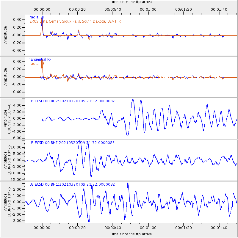
ECSD EROS Data Center, Sioux Falls, South Dakota, USA - Earthquake Result Viewer

| Earthquake location: |
Near East Coast Of Honshu, Japan |
| Earthquake latitude/longitude: |
38.5/141.6 |
| Earthquake time(UTC): |
2021/03/20 (079) 09:09:45 GMT |
| Earthquake Depth: |
54 km |
| Earthquake Magnitude: |
7.0 Mww |
| Earthquake Catalog/Contributor: |
NEIC PDE/us |
|
| Network: |
US United States National Seismic Network |
| Station: |
ECSD EROS Data Center, Sioux Falls, South Dakota, USA |
| Lat/Lon: |
43.73 N/96.61 W |
| Elevation: |
478 m |
|
| Distance: |
82.7 deg |
| Az: |
38.408 deg |
| Baz: |
317.724 deg |
| Ray Param: |
0.04661969 |
| Estimated Moho Depth: |
46.25 km |
| Estimated Crust Vp/Vs: |
2.00 |
| Assumed Crust Vp: |
6.498 km/s |
| Estimated Crust Vs: |
3.253 km/s |
| Estimated Crust Poisson's Ratio: |
0.33 |
|
| Radial Match: |
97.51489 % |
| Radial Bump: |
236 |
| Transverse Match: |
83.855736 % |
| Transverse Bump: |
400 |
| SOD ConfigId: |
24334971 |
| Insert Time: |
2021-04-03 09:44:53.932 +0000 |
| GWidth: |
2.5 |
| Max Bumps: |
400 |
| Tol: |
0.001 |
|
Signal To Noise
| Channel | StoN | STA | LTA |
| US:ECSD:00:BHZ:20210320T09:21:32.000008Z | 8.219674 | 3.2741816E-6 | 3.9833475E-7 |
| US:ECSD:00:BH1:20210320T09:21:32.000008Z | 3.4531138 | 8.652576E-7 | 2.5057315E-7 |
| US:ECSD:00:BH2:20210320T09:21:32.000008Z | 4.194139 | 1.3565159E-6 | 3.234313E-7 |
| Arrivals |
| Ps | 7.3 SECOND |
| PpPs | 21 SECOND |
| PsPs/PpSs | 28 SECOND |


