You are here: Home > Network List > UU - University of Utah Regional Network Stations List
> Station GAWY Genesis Alkali Granger, WY, USA > Earthquake Result Viewer
GAWY Genesis Alkali Granger, WY, USA - Earthquake Result Viewer
| Earthquake location: |
Near East Coast Of Honshu, Japan |
| Earthquake latitude/longitude: |
38.5/141.6 |
| Earthquake time(UTC): |
2021/03/20 (079) 09:09:45 GMT |
| Earthquake Depth: |
54 km |
| Earthquake Magnitude: |
7.0 Mww |
| Earthquake Catalog/Contributor: |
NEIC PDE/us |
|
| Network: |
UU University of Utah Regional Network |
| Station: |
GAWY Genesis Alkali Granger, WY, USA |
| Lat/Lon: |
41.74 N/109.85 W |
| Elevation: |
2011 m |
|
| Distance: |
77.0 deg |
| Az: |
46.725 deg |
| Baz: |
310.217 deg |
| Ray Param: |
0.050486166 |
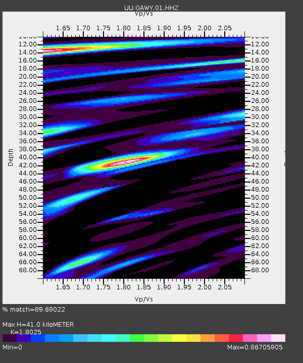
| Estimated Moho Depth: |
41.0 km |
| Estimated Crust Vp/Vs: |
1.80 |
| Assumed Crust Vp: |
6.207 km/s |
| Estimated Crust Vs: |
3.444 km/s |
| Estimated Crust Poisson's Ratio: |
0.28 |
|
| Radial Match: |
89.69022 % |
| Radial Bump: |
400 |
| Transverse Match: |
62.24225 % |
| Transverse Bump: |
400 |
| SOD ConfigId: |
24334971 |
| Insert Time: |
2021-04-03 09:46:01.710 +0000 |
| GWidth: |
2.5 |
| Max Bumps: |
400 |
| Tol: |
0.001 |
|

Signal To Noise
| Channel | StoN | STA | LTA |
| UU:GAWY:01:HHZ:20210320T09:21:01.599984Z | 5.550142 | 8.029293E-8 | 1.4466826E-8 |
| UU:GAWY:01:HHN:20210320T09:21:01.599984Z | 1.3135922 | 1.7796271E-8 | 1.35477904E-8 |
| UU:GAWY:01:HHE:20210320T09:21:01.599984Z | 0.6594628 | 1.717237E-8 | 2.6039938E-8 |
| Arrivals |
| Ps | 5.5 SECOND |
| PpPs | 18 SECOND |
| PsPs/PpSs | 23 SECOND |


