You are here: Home > Network List > WY - Yellowstone Wyoming Seismic Network Stations List
> Station YTP The Promontory, YNP, WY, USA > Earthquake Result Viewer
YTP The Promontory, YNP, WY, USA - Earthquake Result Viewer
| Earthquake location: |
Tonga Islands |
| Earthquake latitude/longitude: |
-15.4/-173.2 |
| Earthquake time(UTC): |
2017/11/04 (308) 09:00:19 GMT |
| Earthquake Depth: |
10 km |
| Earthquake Magnitude: |
6.8 Mww |
| Earthquake Catalog/Contributor: |
NEIC PDE/us |
|
| Network: |
WY Yellowstone Wyoming Seismic Network |
| Station: |
YTP The Promontory, YNP, WY, USA |
| Lat/Lon: |
44.39 N/110.29 W |
| Elevation: |
2384 m |
|
| Distance: |
82.5 deg |
| Az: |
40.089 deg |
| Baz: |
240.064 deg |
| Ray Param: |
0.046872366 |
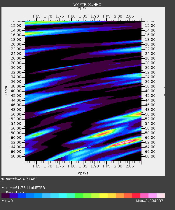
| Estimated Moho Depth: |
61.75 km |
| Estimated Crust Vp/Vs: |
2.03 |
| Assumed Crust Vp: |
6.35 km/s |
| Estimated Crust Vs: |
3.132 km/s |
| Estimated Crust Poisson's Ratio: |
0.34 |
|
| Radial Match: |
94.71463 % |
| Radial Bump: |
336 |
| Transverse Match: |
94.79991 % |
| Transverse Bump: |
397 |
| SOD ConfigId: |
2429771 |
| Insert Time: |
2017-11-18 09:11:27.478 +0000 |
| GWidth: |
2.5 |
| Max Bumps: |
400 |
| Tol: |
0.001 |
|

Signal To Noise
| Channel | StoN | STA | LTA |
| WY:YTP:01:HHZ:20171104T09:12:11.008015Z | 31.55969 | 1.2164061E-7 | 3.854303E-9 |
| WY:YTP:01:HHN:20171104T09:12:11.008015Z | 5.3175917 | 2.8444305E-8 | 5.3490954E-9 |
| WY:YTP:01:HHE:20171104T09:12:11.008015Z | 4.163382 | 2.2613278E-8 | 5.4314686E-9 |
| Arrivals |
| Ps | 10 SECOND |
| PpPs | 29 SECOND |
| PsPs/PpSs | 39 SECOND |


