You are here: Home > Network List > UU - University of Utah Regional Network Stations List
> Station VRUT Veyo Road, Veyo, UT, USA > Earthquake Result Viewer
VRUT Veyo Road, Veyo, UT, USA - Earthquake Result Viewer
| Earthquake location: |
Near East Coast Of Honshu, Japan |
| Earthquake latitude/longitude: |
38.5/141.6 |
| Earthquake time(UTC): |
2021/03/20 (079) 09:09:45 GMT |
| Earthquake Depth: |
54 km |
| Earthquake Magnitude: |
7.0 Mww |
| Earthquake Catalog/Contributor: |
NEIC PDE/us |
|
| Network: |
UU University of Utah Regional Network |
| Station: |
VRUT Veyo Road, Veyo, UT, USA |
| Lat/Lon: |
37.46 N/113.86 W |
| Elevation: |
1874 m |
|
| Distance: |
77.4 deg |
| Az: |
52.123 deg |
| Baz: |
308.868 deg |
| Ray Param: |
0.050268434 |
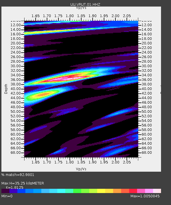
| Estimated Moho Depth: |
35.25 km |
| Estimated Crust Vp/Vs: |
1.81 |
| Assumed Crust Vp: |
6.194 km/s |
| Estimated Crust Vs: |
3.417 km/s |
| Estimated Crust Poisson's Ratio: |
0.28 |
|
| Radial Match: |
92.9801 % |
| Radial Bump: |
380 |
| Transverse Match: |
82.990486 % |
| Transverse Bump: |
400 |
| SOD ConfigId: |
24334971 |
| Insert Time: |
2021-04-03 09:46:27.792 +0000 |
| GWidth: |
2.5 |
| Max Bumps: |
400 |
| Tol: |
0.001 |
|

Signal To Noise
| Channel | StoN | STA | LTA |
| UU:VRUT:01:HHZ:20210320T09:21:03.46003Z | 2.3316116 | 2.239579E-8 | 9.605283E-9 |
| UU:VRUT:01:HHN:20210320T09:21:03.46003Z | 0.89428127 | 6.418766E-9 | 7.177569E-9 |
| UU:VRUT:01:HHE:20210320T09:21:03.46003Z | 0.6987535 | 8.022402E-9 | 1.148102E-8 |
| Arrivals |
| Ps | 4.8 SECOND |
| PpPs | 16 SECOND |
| PsPs/PpSs | 20 SECOND |


