You are here: Home > Network List > ZW13 - Locating North Texas Earthquakes Stations List
> Station IFDF Dallas Firestation > Earthquake Result Viewer
IFDF Dallas Firestation - Earthquake Result Viewer

| Earthquake location: |
Tonga Islands |
| Earthquake latitude/longitude: |
-15.4/-173.2 |
| Earthquake time(UTC): |
2017/11/04 (308) 09:00:19 GMT |
| Earthquake Depth: |
10 km |
| Earthquake Magnitude: |
6.8 Mww |
| Earthquake Catalog/Contributor: |
NEIC PDE/us |
|
| Network: |
ZW Locating North Texas Earthquakes |
| Station: |
IFDF Dallas Firestation |
| Lat/Lon: |
32.78 N/96.90 W |
| Elevation: |
130 m |
|
| Distance: |
87.1 deg |
| Az: |
55.042 deg |
| Baz: |
249.81 deg |
| Ray Param: |
0.043563556 |
| Estimated Moho Depth: |
37.5 km |
| Estimated Crust Vp/Vs: |
1.88 |
| Assumed Crust Vp: |
6.38 km/s |
| Estimated Crust Vs: |
3.394 km/s |
| Estimated Crust Poisson's Ratio: |
0.30 |
|
| Radial Match: |
89.2954 % |
| Radial Bump: |
400 |
| Transverse Match: |
76.52895 % |
| Transverse Bump: |
400 |
| SOD ConfigId: |
2429771 |
| Insert Time: |
2017-11-18 09:11:31.494 +0000 |
| GWidth: |
2.5 |
| Max Bumps: |
400 |
| Tol: |
0.001 |
|
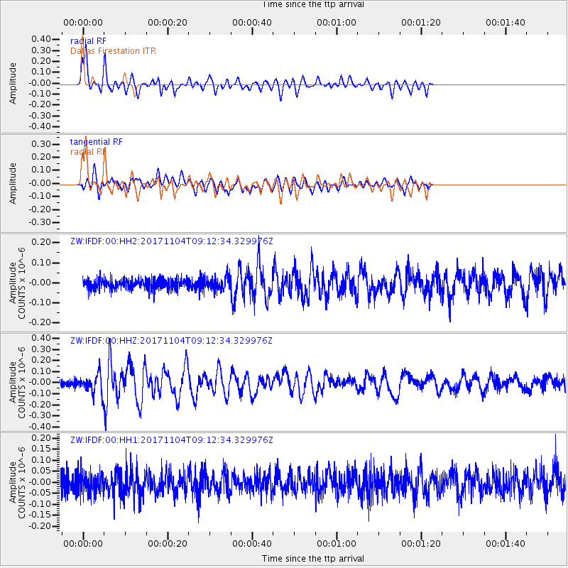
Signal To Noise
| Channel | StoN | STA | LTA |
| ZW:IFDF:00:HHZ:20171104T09:12:34.329976Z | 3.9235487 | 8.545658E-8 | 2.178043E-8 |
| ZW:IFDF:00:HH1:20171104T09:12:34.329976Z | 1.3613096 | 4.6141185E-8 | 3.3894704E-8 |
| ZW:IFDF:00:HH2:20171104T09:12:34.329976Z | 1.2576357 | 3.2150652E-8 | 2.556436E-8 |
| Arrivals |
| Ps | 5.3 SECOND |
| PpPs | 17 SECOND |
| PsPs/PpSs | 22 SECOND |


