You are here: Home > Network List > IU - Global Seismograph Network (GSN - IRIS/USGS) Stations List
> Station NWAO Narrogin, Australia > Earthquake Result Viewer
NWAO Narrogin, Australia - Earthquake Result Viewer
| Earthquake location: |
Loyalty Islands |
| Earthquake latitude/longitude: |
-21.8/169.0 |
| Earthquake time(UTC): |
2017/11/04 (308) 09:27:42 GMT |
| Earthquake Depth: |
9.5 km |
| Earthquake Magnitude: |
5.5 mb |
| Earthquake Catalog/Contributor: |
NEIC PDE/us |
|
| Network: |
IU Global Seismograph Network (GSN - IRIS/USGS) |
| Station: |
NWAO Narrogin, Australia |
| Lat/Lon: |
32.93 S/117.24 E |
| Elevation: |
380 m |
|
| Distance: |
46.9 deg |
| Az: |
244.798 deg |
| Baz: |
89.903 deg |
| Ray Param: |
0.070370264 |
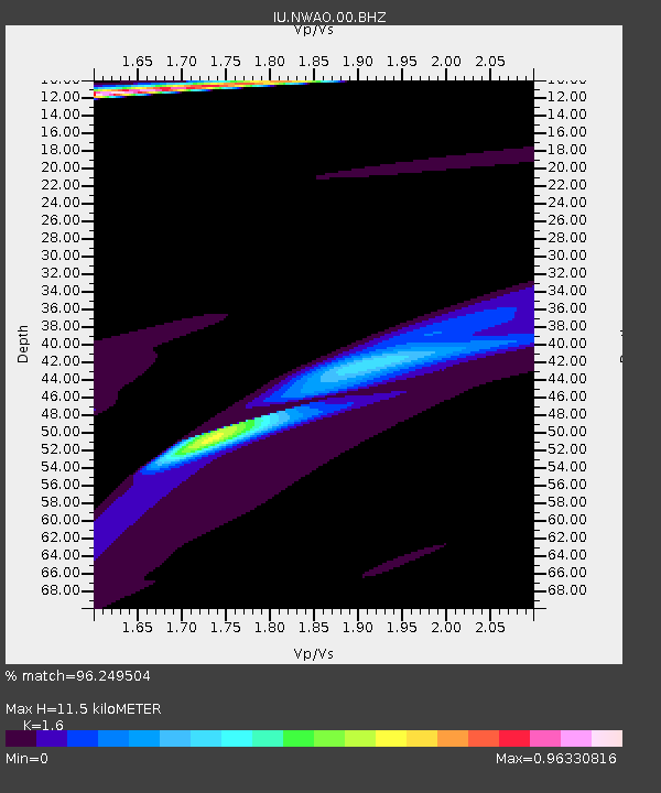
| Estimated Moho Depth: |
11.5 km |
| Estimated Crust Vp/Vs: |
1.60 |
| Assumed Crust Vp: |
6.419 km/s |
| Estimated Crust Vs: |
4.012 km/s |
| Estimated Crust Poisson's Ratio: |
0.18 |
|
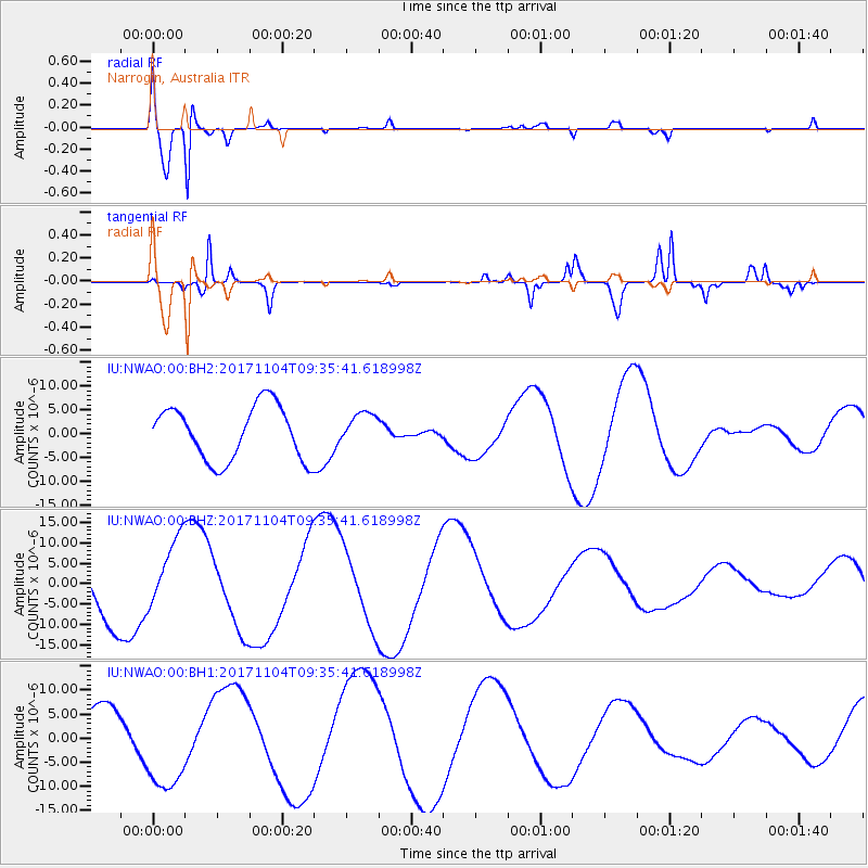
| Radial Match: |
96.249504 % |
| Radial Bump: |
306 |
| Transverse Match: |
72.90626 % |
| Transverse Bump: |
210 |
| SOD ConfigId: |
2429771 |
| Insert Time: |
2017-11-18 09:29:06.419 +0000 |
| GWidth: |
2.5 |
| Max Bumps: |
400 |
| Tol: |
0.001 |
|
Signal To Noise
| Channel | StoN | STA | LTA |
| IU:NWAO:00:BHZ:20171104T09:35:41.618998Z | 1.1068672 | 8.917328E-6 | 8.056367E-6 |
| IU:NWAO:00:BH1:20171104T09:35:41.618998Z | 2.7495294 | 9.6824815E-6 | 3.5215048E-6 |
| IU:NWAO:00:BH2:20171104T09:35:41.618998Z | 0.5937412 | 3.3783174E-6 | 5.6898825E-6 |
| Arrivals |
| Ps | 1.2 SECOND |
| PpPs | 4.3 SECOND |
| PsPs/PpSs | 5.5 SECOND |


