You are here: Home > Network List > GE - GEOFON Stations List
> Station MALT GEOFON/MedNet Station Malatya, Turkey > Earthquake Result Viewer
MALT GEOFON/MedNet Station Malatya, Turkey - Earthquake Result Viewer
| Earthquake location: |
Washington |
| Earthquake latitude/longitude: |
47.1/-122.7 |
| Earthquake time(UTC): |
2001/02/28 (059) 18:54:32 GMT |
| Earthquake Depth: |
52 km |
| Earthquake Magnitude: |
6.5 MB, 6.6 MS, 6.8 MW, 6.7 ME |
| Earthquake Catalog/Contributor: |
WHDF/NEIC |
|
| Network: |
GE GEOFON |
| Station: |
MALT GEOFON/MedNet Station Malatya, Turkey |
| Lat/Lon: |
38.31 N/38.43 E |
| Elevation: |
1120 m |
|
| Distance: |
93.3 deg |
| Az: |
14.745 deg |
| Baz: |
347.242 deg |
| Ray Param: |
0.04127267 |
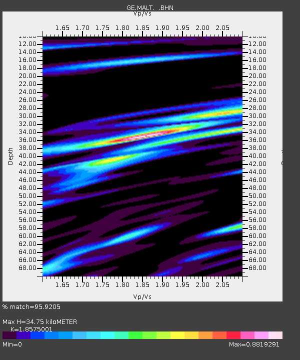
| Estimated Moho Depth: |
34.75 km |
| Estimated Crust Vp/Vs: |
1.86 |
| Assumed Crust Vp: |
6.35 km/s |
| Estimated Crust Vs: |
3.419 km/s |
| Estimated Crust Poisson's Ratio: |
0.30 |
|
| Radial Match: |
95.9205 % |
| Radial Bump: |
400 |
| Transverse Match: |
86.930016 % |
| Transverse Bump: |
400 |
| SOD ConfigId: |
3744 |
| Insert Time: |
2010-03-09 06:46:08.433 +0000 |
| GWidth: |
2.5 |
| Max Bumps: |
400 |
| Tol: |
0.001 |
|

Signal To Noise
| Channel | StoN | STA | LTA |
| GE:MALT: :BHN:20010228T19:07:10.564009Z | 9.329101 | 3.33908E-7 | 3.579209E-8 |
| GE:MALT: :BHE:20010228T19:07:10.564009Z | 4.1135044 | 1.3656235E-7 | 3.3198543E-8 |
| GE:MALT: :BHZ:20010228T19:07:10.564009Z | 9.495097 | 9.954811E-7 | 1.0484158E-7 |
| Arrivals |
| Ps | 4.8 SECOND |
| PpPs | 15 SECOND |
| PsPs/PpSs | 20 SECOND |


