You are here: Home > Network List > UW - Pacific Northwest Regional Seismic Network Stations List
> Station SHUK Shuksan (Mt. Baker Ski Area), WA > Earthquake Result Viewer
SHUK Shuksan (Mt. Baker Ski Area), WA - Earthquake Result Viewer
| Earthquake location: |
Near East Coast Of Honshu, Japan |
| Earthquake latitude/longitude: |
38.5/141.6 |
| Earthquake time(UTC): |
2021/03/20 (079) 09:09:45 GMT |
| Earthquake Depth: |
54 km |
| Earthquake Magnitude: |
7.0 Mww |
| Earthquake Catalog/Contributor: |
NEIC PDE/us |
|
| Network: |
UW Pacific Northwest Regional Seismic Network |
| Station: |
SHUK Shuksan (Mt. Baker Ski Area), WA |
| Lat/Lon: |
48.85 N/121.68 W |
| Elevation: |
1516 m |
|
| Distance: |
66.1 deg |
| Az: |
45.832 deg |
| Baz: |
301.526 deg |
| Ray Param: |
0.05770174 |
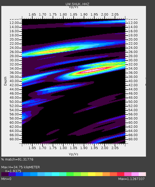
| Estimated Moho Depth: |
34.75 km |
| Estimated Crust Vp/Vs: |
1.94 |
| Assumed Crust Vp: |
6.566 km/s |
| Estimated Crust Vs: |
3.389 km/s |
| Estimated Crust Poisson's Ratio: |
0.32 |
|
| Radial Match: |
91.31776 % |
| Radial Bump: |
379 |
| Transverse Match: |
89.502785 % |
| Transverse Bump: |
400 |
| SOD ConfigId: |
24334971 |
| Insert Time: |
2021-04-03 09:47:33.330 +0000 |
| GWidth: |
2.5 |
| Max Bumps: |
400 |
| Tol: |
0.001 |
|

Signal To Noise
| Channel | StoN | STA | LTA |
| UW:SHUK: :HHZ:20210320T09:19:56.180001Z | 6.828487 | 1.940931E-6 | 2.842403E-7 |
| UW:SHUK: :HHN:20210320T09:19:56.180001Z | 0.8124817 | 4.575641E-7 | 5.631685E-7 |
| UW:SHUK: :HHE:20210320T09:19:56.180001Z | 2.1043959 | 7.598339E-7 | 3.6106982E-7 |
| Arrivals |
| Ps | 5.2 SECOND |
| PpPs | 15 SECOND |
| PsPs/PpSs | 20 SECOND |


