You are here: Home > Network List > WY - Yellowstone Wyoming Seismic Network Stations List
> Station YNE Northeast Entrance, YNP, WY, USA > Earthquake Result Viewer
YNE Northeast Entrance, YNP, WY, USA - Earthquake Result Viewer
| Earthquake location: |
Near East Coast Of Honshu, Japan |
| Earthquake latitude/longitude: |
38.5/141.6 |
| Earthquake time(UTC): |
2021/03/20 (079) 09:09:45 GMT |
| Earthquake Depth: |
54 km |
| Earthquake Magnitude: |
7.0 Mww |
| Earthquake Catalog/Contributor: |
NEIC PDE/us |
|
| Network: |
WY Yellowstone Wyoming Seismic Network |
| Station: |
YNE Northeast Entrance, YNP, WY, USA |
| Lat/Lon: |
45.01 N/110.01 W |
| Elevation: |
2343 m |
|
| Distance: |
74.9 deg |
| Az: |
44.216 deg |
| Baz: |
309.501 deg |
| Ray Param: |
0.051947374 |
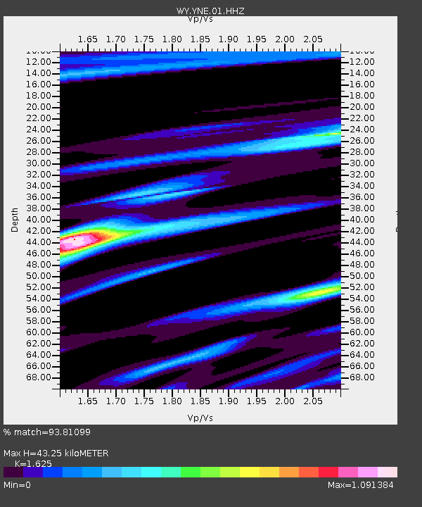
| Estimated Moho Depth: |
43.25 km |
| Estimated Crust Vp/Vs: |
1.62 |
| Assumed Crust Vp: |
6.35 km/s |
| Estimated Crust Vs: |
3.908 km/s |
| Estimated Crust Poisson's Ratio: |
0.20 |
|
| Radial Match: |
93.81099 % |
| Radial Bump: |
398 |
| Transverse Match: |
89.98108 % |
| Transverse Bump: |
400 |
| SOD ConfigId: |
24334971 |
| Insert Time: |
2021-04-03 09:48:38.663 +0000 |
| GWidth: |
2.5 |
| Max Bumps: |
400 |
| Tol: |
0.001 |
|

Signal To Noise
| Channel | StoN | STA | LTA |
| WY:YNE:01:HHZ:20210320T09:20:49.219979Z | 5.7140336 | 3.951816E-8 | 6.915983E-9 |
| WY:YNE:01:HHN:20210320T09:20:49.219979Z | 1.5190989 | 1.3873443E-8 | 9.1326795E-9 |
| WY:YNE:01:HHE:20210320T09:20:49.219979Z | 1.1133924 | 1.291999E-8 | 1.16041665E-8 |
| Arrivals |
| Ps | 4.4 SECOND |
| PpPs | 17 SECOND |
| PsPs/PpSs | 22 SECOND |


