You are here: Home > Network List > WY - Yellowstone Wyoming Seismic Network Stations List
> Station YNR Norris Junction, YNP, WY, USA > Earthquake Result Viewer
YNR Norris Junction, YNP, WY, USA - Earthquake Result Viewer
| Earthquake location: |
Near East Coast Of Honshu, Japan |
| Earthquake latitude/longitude: |
38.5/141.6 |
| Earthquake time(UTC): |
2021/03/20 (079) 09:09:45 GMT |
| Earthquake Depth: |
54 km |
| Earthquake Magnitude: |
7.0 Mww |
| Earthquake Catalog/Contributor: |
NEIC PDE/us |
|
| Network: |
WY Yellowstone Wyoming Seismic Network |
| Station: |
YNR Norris Junction, YNP, WY, USA |
| Lat/Lon: |
44.72 N/110.68 W |
| Elevation: |
2336 m |
|
| Distance: |
74.7 deg |
| Az: |
44.764 deg |
| Baz: |
309.173 deg |
| Ray Param: |
0.05206762 |
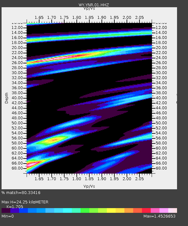
| Estimated Moho Depth: |
24.25 km |
| Estimated Crust Vp/Vs: |
1.71 |
| Assumed Crust Vp: |
6.35 km/s |
| Estimated Crust Vs: |
3.724 km/s |
| Estimated Crust Poisson's Ratio: |
0.24 |
|
| Radial Match: |
80.33416 % |
| Radial Bump: |
400 |
| Transverse Match: |
75.7809 % |
| Transverse Bump: |
400 |
| SOD ConfigId: |
24334971 |
| Insert Time: |
2021-04-03 09:48:39.623 +0000 |
| GWidth: |
2.5 |
| Max Bumps: |
400 |
| Tol: |
0.001 |
|

Signal To Noise
| Channel | StoN | STA | LTA |
| WY:YNR:01:HHZ:20210320T09:20:48.158028Z | 4.602207 | 2.2242157E-8 | 4.8329327E-9 |
| WY:YNR:01:HHN:20210320T09:20:48.158028Z | 1.4683362 | 8.783378E-9 | 5.981857E-9 |
| WY:YNR:01:HHE:20210320T09:20:48.158028Z | 3.0763688 | 1.6308057E-8 | 5.301074E-9 |
| Arrivals |
| Ps | 2.8 SECOND |
| PpPs | 10.0 SECOND |
| PsPs/PpSs | 13 SECOND |


