You are here: Home > Network List > PQ - Public Safety Geoscience Program Canadian Research Network (PSGP) Stations List
> Station HAKB Hakai Institute, Calvert Island, BC > Earthquake Result Viewer
HAKB Hakai Institute, Calvert Island, BC - Earthquake Result Viewer
| Earthquake location: |
Near East Coast Of Honshu, Japan |
| Earthquake latitude/longitude: |
38.5/141.6 |
| Earthquake time(UTC): |
2021/03/20 (079) 09:09:45 GMT |
| Earthquake Depth: |
54 km |
| Earthquake Magnitude: |
7.0 Mww |
| Earthquake Catalog/Contributor: |
NEIC PDE/us |
|
| Network: |
PQ Public Safety Geoscience Program Canadian Research Network (PSGP) |
| Station: |
HAKB Hakai Institute, Calvert Island, BC |
| Lat/Lon: |
51.65 N/128.14 W |
| Elevation: |
45 m |
|
| Distance: |
61.2 deg |
| Az: |
45.344 deg |
| Baz: |
296.348 deg |
| Ray Param: |
0.060936034 |
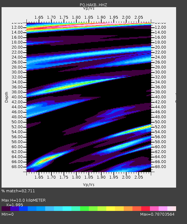
| Estimated Moho Depth: |
10.0 km |
| Estimated Crust Vp/Vs: |
2.00 |
| Assumed Crust Vp: |
6.24 km/s |
| Estimated Crust Vs: |
3.128 km/s |
| Estimated Crust Poisson's Ratio: |
0.33 |
|
| Radial Match: |
82.711 % |
| Radial Bump: |
369 |
| Transverse Match: |
66.8068 % |
| Transverse Bump: |
400 |
| SOD ConfigId: |
24334971 |
| Insert Time: |
2021-04-03 09:49:27.887 +0000 |
| GWidth: |
2.5 |
| Max Bumps: |
400 |
| Tol: |
0.001 |
|

Signal To Noise
| Channel | StoN | STA | LTA |
| PQ:HAKB: :HHZ:20210320T09:19:23.430001Z | 2.2019453 | 2.0102352E-6 | 9.1293606E-7 |
| PQ:HAKB: :HHN:20210320T09:19:23.430001Z | 0.8956355 | 6.29739E-7 | 7.031198E-7 |
| PQ:HAKB: :HHE:20210320T09:19:23.430001Z | 1.0120211 | 1.0846478E-6 | 1.071764E-6 |
| Arrivals |
| Ps | 1.7 SECOND |
| PpPs | 4.6 SECOND |
| PsPs/PpSs | 6.3 SECOND |


