You are here: Home > Network List > UW - Pacific Northwest Regional Seismic Network Stations List
> Station FISH Seaside, OR, USA > Earthquake Result Viewer
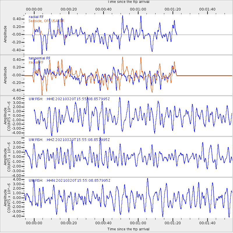
FISH Seaside, OR, USA - Earthquake Result Viewer
*The percent match for this event was below the threshold and hence no stack was calculated.
| Earthquake location: |
Southeast Of Loyalty Islands |
| Earthquake latitude/longitude: |
-23.2/171.7 |
| Earthquake time(UTC): |
2021/03/20 (079) 15:42:39 GMT |
| Earthquake Depth: |
10 km |
| Earthquake Magnitude: |
5.5 Mww |
| Earthquake Catalog/Contributor: |
NEIC PDE/us |
|
| Network: |
UW Pacific Northwest Regional Seismic Network |
| Station: |
FISH Seaside, OR, USA |
| Lat/Lon: |
45.93 N/123.56 W |
| Elevation: |
325 m |
|
| Distance: |
90.4 deg |
| Az: |
39.158 deg |
| Baz: |
236.377 deg |
| Ray Param: |
$rayparam |
*The percent match for this event was below the threshold and hence was not used in the summary stack. |
|
| Radial Match: |
61.701366 % |
| Radial Bump: |
400 |
| Transverse Match: |
39.469826 % |
| Transverse Bump: |
400 |
| SOD ConfigId: |
24334971 |
| Insert Time: |
2021-04-03 15:54:33.327 +0000 |
| GWidth: |
2.5 |
| Max Bumps: |
400 |
| Tol: |
0.001 |
|
Signal To Noise
| Channel | StoN | STA | LTA |
| UW:FISH: :HHZ:20210320T15:55:08.857995Z | 1.3827317 | 1.352101E-6 | 9.778478E-7 |
| UW:FISH: :HHN:20210320T15:55:08.857995Z | 1.2177777 | 1.7838007E-6 | 1.4647999E-6 |
| UW:FISH: :HHE:20210320T15:55:08.857995Z | 1.3482648 | 2.2413567E-6 | 1.662401E-6 |
| Arrivals |
| Ps | |
| PpPs | |
| PsPs/PpSs | |


