You are here: Home > Network List > AV - Alaska Volcano Observatory Stations List
> Station MAPS Pakushin Southeast, Makushin Volcano, Alaska > Earthquake Result Viewer
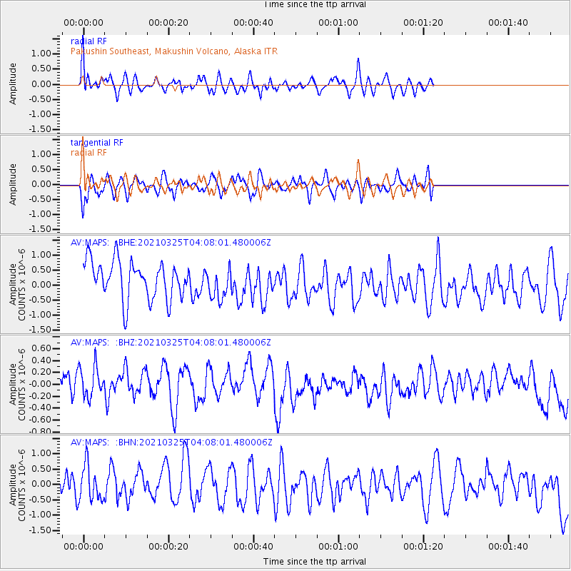
MAPS Pakushin Southeast, Makushin Volcano, Alaska - Earthquake Result Viewer
*The percent match for this event was below the threshold and hence no stack was calculated.
| Earthquake location: |
South Of Fiji Islands |
| Earthquake latitude/longitude: |
-26.1/178.4 |
| Earthquake time(UTC): |
2021/03/25 (084) 03:57:21 GMT |
| Earthquake Depth: |
598 km |
| Earthquake Magnitude: |
5.5 mww |
| Earthquake Catalog/Contributor: |
NEIC PDE/us |
|
| Network: |
AV Alaska Volcano Observatory |
| Station: |
MAPS Pakushin Southeast, Makushin Volcano, Alaska |
| Lat/Lon: |
53.81 N/166.94 W |
| Elevation: |
333 m |
|
| Distance: |
80.6 deg |
| Az: |
8.732 deg |
| Baz: |
193.305 deg |
| Ray Param: |
$rayparam |
*The percent match for this event was below the threshold and hence was not used in the summary stack. |
|
| Radial Match: |
64.02608 % |
| Radial Bump: |
400 |
| Transverse Match: |
66.16483 % |
| Transverse Bump: |
400 |
| SOD ConfigId: |
24334971 |
| Insert Time: |
2021-04-08 04:01:43.551 +0000 |
| GWidth: |
2.5 |
| Max Bumps: |
400 |
| Tol: |
0.001 |
|
Signal To Noise
| Channel | StoN | STA | LTA |
| AV:MAPS: :BHZ:20210325T04:08:01.480006Z | 1.223682 | 3.3453685E-7 | 2.7338544E-7 |
| AV:MAPS: :BHN:20210325T04:08:01.480006Z | 1.015 | 6.975326E-7 | 6.872242E-7 |
| AV:MAPS: :BHE:20210325T04:08:01.480006Z | 0.8459759 | 5.305623E-7 | 6.271601E-7 |
| Arrivals |
| Ps | |
| PpPs | |
| PsPs/PpSs | |


