You are here: Home > Network List > AV - Alaska Volcano Observatory Stations List
> Station PLBL Mt. Peulik Volcano, Alaska > Earthquake Result Viewer
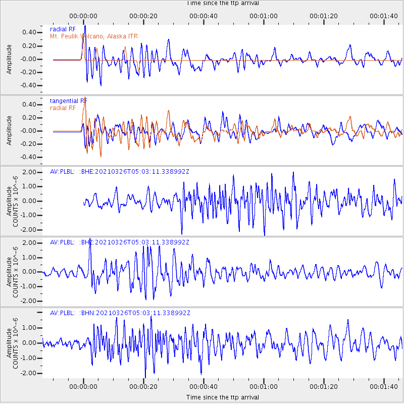
PLBL Mt. Peulik Volcano, Alaska - Earthquake Result Viewer
*The percent match for this event was below the threshold and hence no stack was calculated.
| Earthquake location: |
Leeward Islands |
| Earthquake latitude/longitude: |
16.7/-60.8 |
| Earthquake time(UTC): |
2021/03/26 (085) 04:51:39 GMT |
| Earthquake Depth: |
26 km |
| Earthquake Magnitude: |
5.8 mww |
| Earthquake Catalog/Contributor: |
NEIC PDE/us |
|
| Network: |
AV Alaska Volcano Observatory |
| Station: |
PLBL Mt. Peulik Volcano, Alaska |
| Lat/Lon: |
57.70 N/156.82 W |
| Elevation: |
461 m |
|
| Distance: |
79.2 deg |
| Az: |
327.074 deg |
| Baz: |
75.994 deg |
| Ray Param: |
$rayparam |
*The percent match for this event was below the threshold and hence was not used in the summary stack. |
|
| Radial Match: |
67.611275 % |
| Radial Bump: |
400 |
| Transverse Match: |
60.41498 % |
| Transverse Bump: |
400 |
| SOD ConfigId: |
24334971 |
| Insert Time: |
2021-04-09 04:58:32.208 +0000 |
| GWidth: |
2.5 |
| Max Bumps: |
400 |
| Tol: |
0.001 |
|
Signal To Noise
| Channel | StoN | STA | LTA |
| AV:PLBL: :BHZ:20210326T05:03:11.338992Z | 4.0628157 | 8.3600065E-7 | 2.0576879E-7 |
| AV:PLBL: :BHN:20210326T05:03:11.338992Z | 1.6140455 | 5.971492E-7 | 3.699705E-7 |
| AV:PLBL: :BHE:20210326T05:03:11.338992Z | 1.9619772 | 7.3309707E-7 | 3.7365217E-7 |
| Arrivals |
| Ps | |
| PpPs | |
| PsPs/PpSs | |


