You are here: Home > Network List > AZ - ANZA Regional Network Stations List
> Station SMER AZ.SMER > Earthquake Result Viewer
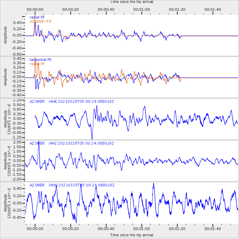
SMER AZ.SMER - Earthquake Result Viewer
*The percent match for this event was below the threshold and hence no stack was calculated.
| Earthquake location: |
Leeward Islands |
| Earthquake latitude/longitude: |
16.7/-60.8 |
| Earthquake time(UTC): |
2021/03/26 (085) 04:51:39 GMT |
| Earthquake Depth: |
26 km |
| Earthquake Magnitude: |
5.8 mww |
| Earthquake Catalog/Contributor: |
NEIC PDE/us |
|
| Network: |
AZ ANZA Regional Network |
| Station: |
SMER AZ.SMER |
| Lat/Lon: |
33.46 N/117.17 W |
| Elevation: |
355 m |
|
| Distance: |
53.1 deg |
| Az: |
299.503 deg |
| Baz: |
93.793 deg |
| Ray Param: |
$rayparam |
*The percent match for this event was below the threshold and hence was not used in the summary stack. |
|
| Radial Match: |
76.31155 % |
| Radial Bump: |
320 |
| Transverse Match: |
55.67801 % |
| Transverse Bump: |
319 |
| SOD ConfigId: |
24334971 |
| Insert Time: |
2021-04-09 04:59:24.540 +0000 |
| GWidth: |
2.5 |
| Max Bumps: |
400 |
| Tol: |
0.001 |
|
Signal To Noise
| Channel | StoN | STA | LTA |
| AZ:SMER: :HHZ:20210326T05:00:24.088016Z | 3.2682748 | 7.4812857E-7 | 2.2890625E-7 |
| AZ:SMER: :HHN:20210326T05:00:24.088016Z | 1.1974882 | 2.393489E-7 | 1.998758E-7 |
| AZ:SMER: :HHE:20210326T05:00:24.088016Z | 2.307135 | 5.699074E-7 | 2.470195E-7 |
| Arrivals |
| Ps | |
| PpPs | |
| PsPs/PpSs | |


