You are here: Home > Network List > BL - Brazilian Lithospheric Seismic Project (BLSP) Stations List
> Station PMNB Patos de Minas, MG > Earthquake Result Viewer
PMNB Patos de Minas, MG - Earthquake Result Viewer
| Earthquake location: |
Leeward Islands |
| Earthquake latitude/longitude: |
16.7/-60.8 |
| Earthquake time(UTC): |
2021/03/26 (085) 04:51:39 GMT |
| Earthquake Depth: |
26 km |
| Earthquake Magnitude: |
5.8 mww |
| Earthquake Catalog/Contributor: |
NEIC PDE/us |
|
| Network: |
BL Brazilian Lithospheric Seismic Project (BLSP) |
| Station: |
PMNB Patos de Minas, MG |
| Lat/Lon: |
18.54 S/46.44 W |
| Elevation: |
950 m |
|
| Distance: |
37.8 deg |
| Az: |
157.371 deg |
| Baz: |
337.127 deg |
| Ray Param: |
0.07591874 |
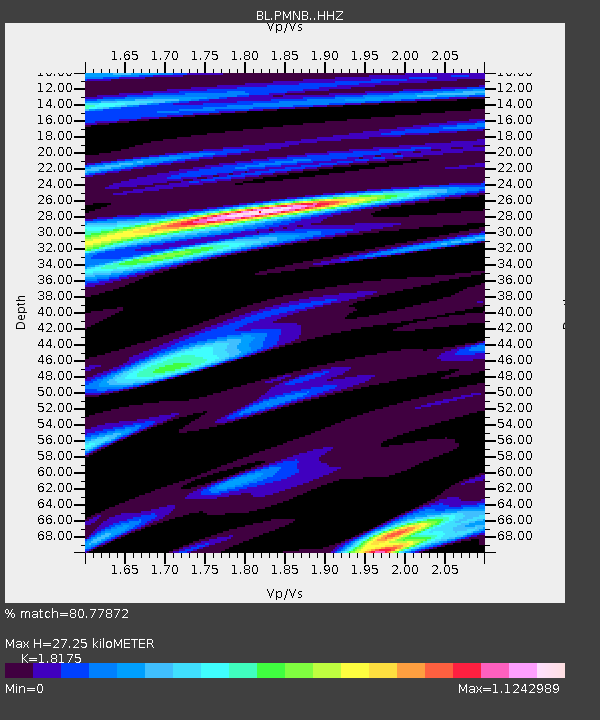
| Estimated Moho Depth: |
27.25 km |
| Estimated Crust Vp/Vs: |
1.82 |
| Assumed Crust Vp: |
6.419 km/s |
| Estimated Crust Vs: |
3.532 km/s |
| Estimated Crust Poisson's Ratio: |
0.28 |
|
| Radial Match: |
80.77872 % |
| Radial Bump: |
400 |
| Transverse Match: |
75.3264 % |
| Transverse Bump: |
400 |
| SOD ConfigId: |
24334971 |
| Insert Time: |
2021-04-09 05:00:03.917 +0000 |
| GWidth: |
2.5 |
| Max Bumps: |
400 |
| Tol: |
0.001 |
|

Signal To Noise
| Channel | StoN | STA | LTA |
| BL:PMNB: :HHZ:20210326T04:58:22.82001Z | 4.9465914 | 8.797532E-7 | 1.778504E-7 |
| BL:PMNB: :HHN:20210326T04:58:22.82001Z | 3.9929175 | 4.384141E-7 | 1.0979794E-7 |
| BL:PMNB: :HHE:20210326T04:58:22.82001Z | 1.8812683 | 2.4841833E-7 | 1.3204833E-7 |
| Arrivals |
| Ps | 3.7 SECOND |
| PpPs | 11 SECOND |
| PsPs/PpSs | 15 SECOND |


