You are here: Home > Network List > CI - Caltech Regional Seismic Network Stations List
> Station SMM Simmler, CA, USA > Earthquake Result Viewer
SMM Simmler, CA, USA - Earthquake Result Viewer
*The percent match for this event was below the threshold and hence no stack was calculated.
| Earthquake location: |
Leeward Islands |
| Earthquake latitude/longitude: |
16.7/-60.8 |
| Earthquake time(UTC): |
2021/03/26 (085) 04:51:39 GMT |
| Earthquake Depth: |
26 km |
| Earthquake Magnitude: |
5.8 mww |
| Earthquake Catalog/Contributor: |
NEIC PDE/us |
|
| Network: |
CI Caltech Regional Seismic Network |
| Station: |
SMM Simmler, CA, USA |
| Lat/Lon: |
35.31 N/120.00 W |
| Elevation: |
599 m |
|
| Distance: |
55.5 deg |
| Az: |
301.597 deg |
| Baz: |
93.426 deg |
| Ray Param: |
$rayparam |
*The percent match for this event was below the threshold and hence was not used in the summary stack. |
|
| Radial Match: |
58.295277 % |
| Radial Bump: |
400 |
| Transverse Match: |
58.64233 % |
| Transverse Bump: |
400 |
| SOD ConfigId: |
24334971 |
| Insert Time: |
2021-04-09 05:04:28.654 +0000 |
| GWidth: |
2.5 |
| Max Bumps: |
400 |
| Tol: |
0.001 |
|
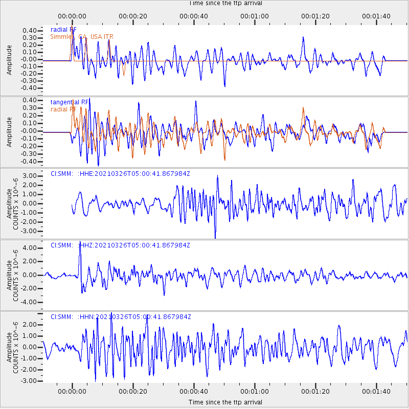
Signal To Noise
| Channel | StoN | STA | LTA |
| CI:SMM: :HHZ:20210326T05:00:41.867984Z | 5.0729804 | 1.7181898E-6 | 3.3869435E-7 |
| CI:SMM: :HHN:20210326T05:00:41.867984Z | 0.7042628 | 6.6308655E-7 | 9.4153285E-7 |
| CI:SMM: :HHE:20210326T05:00:41.867984Z | 1.6148973 | 8.63616E-7 | 5.347808E-7 |
| Arrivals |
| Ps | |
| PpPs | |
| PsPs/PpSs | |


