You are here: Home > Network List > CI - Caltech Regional Seismic Network Stations List
> Station TIN Tinemaha, Big Pine, CA, USA > Earthquake Result Viewer
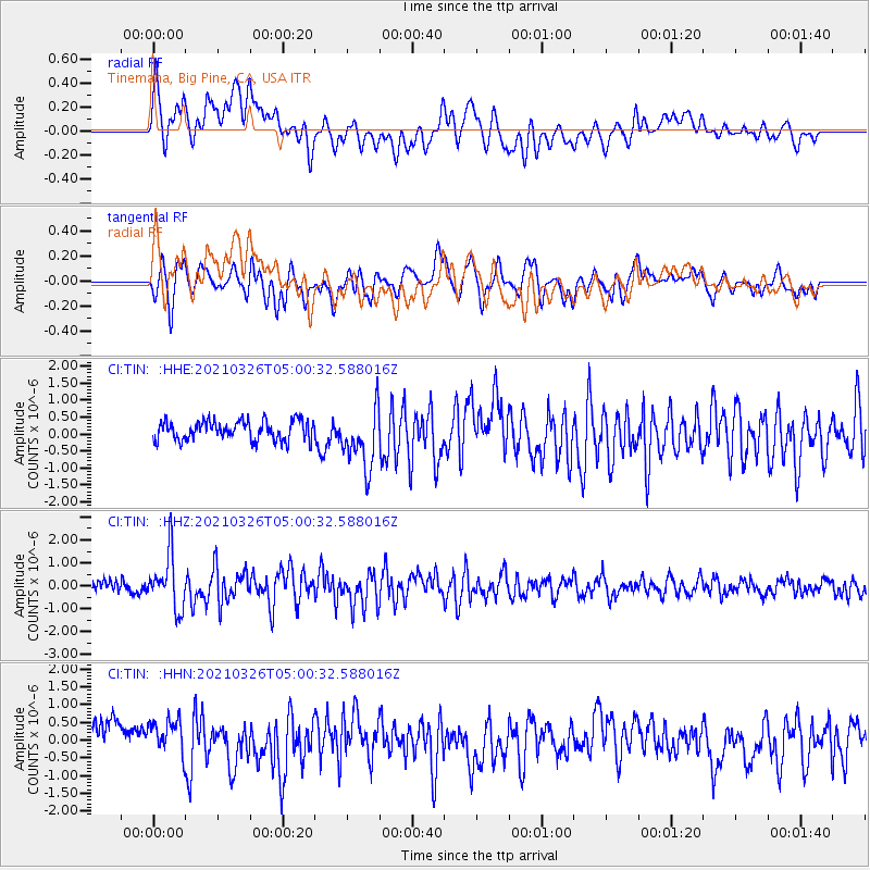
TIN Tinemaha, Big Pine, CA, USA - Earthquake Result Viewer
*The percent match for this event was below the threshold and hence no stack was calculated.
| Earthquake location: |
Leeward Islands |
| Earthquake latitude/longitude: |
16.7/-60.8 |
| Earthquake time(UTC): |
2021/03/26 (085) 04:51:39 GMT |
| Earthquake Depth: |
26 km |
| Earthquake Magnitude: |
5.8 mww |
| Earthquake Catalog/Contributor: |
NEIC PDE/us |
|
| Network: |
CI Caltech Regional Seismic Network |
| Station: |
TIN Tinemaha, Big Pine, CA, USA |
| Lat/Lon: |
37.05 N/118.23 W |
| Elevation: |
1197 m |
|
| Distance: |
54.3 deg |
| Az: |
303.852 deg |
| Baz: |
95.761 deg |
| Ray Param: |
$rayparam |
*The percent match for this event was below the threshold and hence was not used in the summary stack. |
|
| Radial Match: |
70.56339 % |
| Radial Bump: |
400 |
| Transverse Match: |
61.045616 % |
| Transverse Bump: |
400 |
| SOD ConfigId: |
24334971 |
| Insert Time: |
2021-04-09 05:04:37.575 +0000 |
| GWidth: |
2.5 |
| Max Bumps: |
400 |
| Tol: |
0.001 |
|
Signal To Noise
| Channel | StoN | STA | LTA |
| CI:TIN: :HHZ:20210326T05:00:32.588016Z | 4.3284063 | 1.1572225E-6 | 2.6735535E-7 |
| CI:TIN: :HHN:20210326T05:00:32.588016Z | 1.2188976 | 5.6095803E-7 | 4.602175E-7 |
| CI:TIN: :HHE:20210326T05:00:32.588016Z | 3.0954516 | 8.8592697E-7 | 2.862028E-7 |
| Arrivals |
| Ps | |
| PpPs | |
| PsPs/PpSs | |


