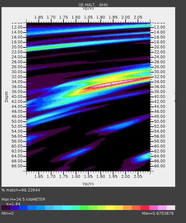
MALT GEOFON/MedNet Station Malatya, Turkey - Earthquake Result Viewer

Earthquake location: Southwest Of Sumatra, Indonesia
Earthquake latitude/longitude: -6.2/103.1
Earthquake time(UTC): 2005/05/10 (130) 01:09:05 GMT
Earthquake Depth: 17 km
Earthquake Magnitude: 5.9 MB, 6.4 MS, 6.2 MW, 6.2 MW
Earthquake Catalog/Contributor: WHDF/NEIC
Network: GE GEOFON
Station: MALT GEOFON/MedNet Station Malatya, Turkey
Lat/Lon: 38.31 N/38.43 E
Elevation: 1120 m
Distance: 74.5 deg
Az: 312.423 deg
Baz: 111.105 deg
Ray Param: 0.05229141
Estimated Moho Depth: 34.5 km
Estimated Crust Vp/Vs: 1.94
Assumed Crust Vp: 6.35 km/s
Estimated Crust Vs: 3.273 km/s
Estimated Crust Poisson's Ratio: 0.32
Radial Match: 96.22944 %
Radial Bump: 357
Transverse Match: 81.98883 %
Transverse Bump: 400
SOD ConfigId: 2455
Insert Time: 2010-03-09 06:50:13.813 +0000
GWidth: 2.5
Max Bumps: 400
Tol: 0.001

Signal To Noise

ChannelStoNSTALTA
GE:MALT: :BHN:20050510T01:20:11.141016Z7.55582141.3454785E-71.7807176E-8
GE:MALT: :BHE:20050510T01:20:11.141016Z23.5510084.5142735E-71.9168068E-8
GE:MALT: :BHZ:20050510T01:20:11.141016Z40.4234961.3184225E-63.261525E-8
Arrivals
Ps5.3 SECOND
PpPs16 SECOND
PsPs/PpSs21 SECOND