You are here: Home > Network List > GS - US Geological Survey Networks Stations List
> Station DEC06 Boomer > Earthquake Result Viewer
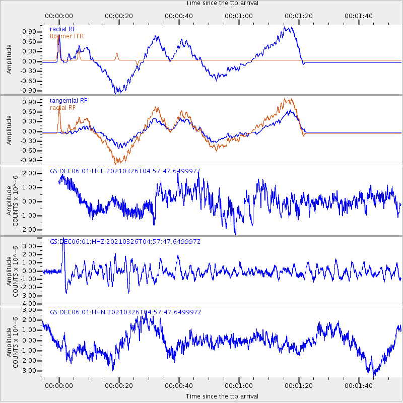
DEC06 Boomer - Earthquake Result Viewer
*The percent match for this event was below the threshold and hence no stack was calculated.
| Earthquake location: |
Leeward Islands |
| Earthquake latitude/longitude: |
16.7/-60.8 |
| Earthquake time(UTC): |
2021/03/26 (085) 04:51:39 GMT |
| Earthquake Depth: |
26 km |
| Earthquake Magnitude: |
5.8 mww |
| Earthquake Catalog/Contributor: |
NEIC PDE/us |
|
| Network: |
GS US Geological Survey Networks |
| Station: |
DEC06 Boomer |
| Lat/Lon: |
39.90 N/88.95 W |
| Elevation: |
215 m |
|
| Distance: |
33.6 deg |
| Az: |
319.103 deg |
| Baz: |
125.348 deg |
| Ray Param: |
$rayparam |
*The percent match for this event was below the threshold and hence was not used in the summary stack. |
|
| Radial Match: |
46.7311 % |
| Radial Bump: |
400 |
| Transverse Match: |
42.139233 % |
| Transverse Bump: |
400 |
| SOD ConfigId: |
24334971 |
| Insert Time: |
2021-04-09 05:08:07.071 +0000 |
| GWidth: |
2.5 |
| Max Bumps: |
400 |
| Tol: |
0.001 |
|
Signal To Noise
| Channel | StoN | STA | LTA |
| GS:DEC06:01:HHZ:20210326T04:57:47.649997Z | 9.915103 | 1.5882973E-6 | 1.6018969E-7 |
| GS:DEC06:01:HHN:20210326T04:57:47.649997Z | 0.55070496 | 9.924132E-7 | 1.8020779E-6 |
| GS:DEC06:01:HHE:20210326T04:57:47.649997Z | 0.96980387 | 8.014801E-7 | 8.2643527E-7 |
| Arrivals |
| Ps | |
| PpPs | |
| PsPs/PpSs | |


