You are here: Home > Network List > GS - US Geological Survey Networks Stations List
> Station KS28 W Mills Ave, Hutchinson KS > Earthquake Result Viewer
KS28 W Mills Ave, Hutchinson KS - Earthquake Result Viewer
| Earthquake location: |
Leeward Islands |
| Earthquake latitude/longitude: |
16.7/-60.8 |
| Earthquake time(UTC): |
2021/03/26 (085) 04:51:39 GMT |
| Earthquake Depth: |
26 km |
| Earthquake Magnitude: |
5.8 mww |
| Earthquake Catalog/Contributor: |
NEIC PDE/us |
|
| Network: |
GS US Geological Survey Networks |
| Station: |
KS28 W Mills Ave, Hutchinson KS |
| Lat/Lon: |
37.99 N/97.99 W |
| Elevation: |
482 m |
|
| Distance: |
38.9 deg |
| Az: |
310.512 deg |
| Baz: |
112.739 deg |
| Ray Param: |
0.07527699 |
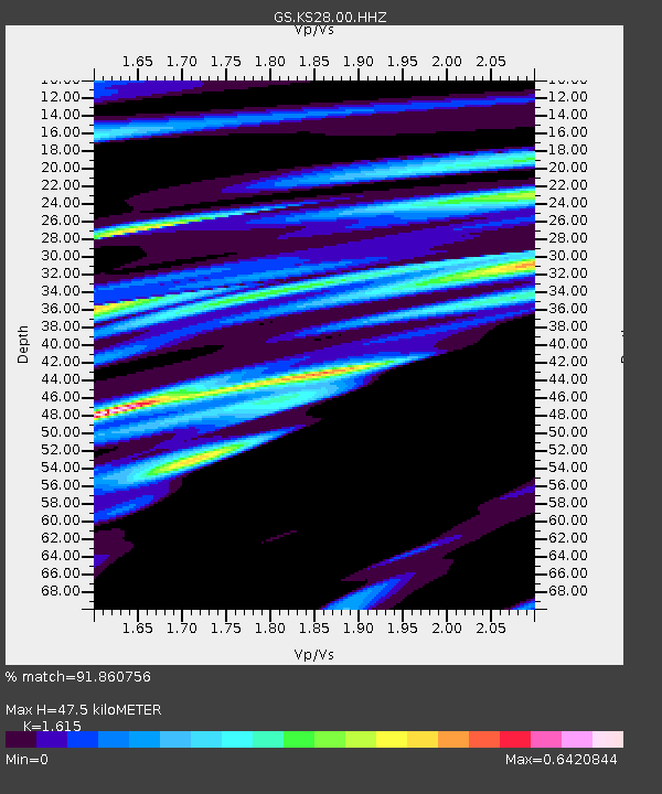
| Estimated Moho Depth: |
47.5 km |
| Estimated Crust Vp/Vs: |
1.62 |
| Assumed Crust Vp: |
6.483 km/s |
| Estimated Crust Vs: |
4.014 km/s |
| Estimated Crust Poisson's Ratio: |
0.19 |
|
| Radial Match: |
91.860756 % |
| Radial Bump: |
400 |
| Transverse Match: |
48.559383 % |
| Transverse Bump: |
400 |
| SOD ConfigId: |
24334971 |
| Insert Time: |
2021-04-09 05:08:10.939 +0000 |
| GWidth: |
2.5 |
| Max Bumps: |
400 |
| Tol: |
0.001 |
|

Signal To Noise
| Channel | StoN | STA | LTA |
| GS:KS28:00:HHZ:20210326T04:58:32.464999Z | 17.777666 | 2.195097E-6 | 1.2347499E-7 |
| GS:KS28:00:HH1:20210326T04:58:32.464999Z | 2.0515227 | 5.260431E-7 | 2.5641594E-7 |
| GS:KS28:00:HH2:20210326T04:58:32.464999Z | 9.98062 | 1.5188308E-6 | 1.5217799E-7 |
| Arrivals |
| Ps | 4.9 SECOND |
| PpPs | 18 SECOND |
| PsPs/PpSs | 23 SECOND |


