You are here: Home > Network List > GE - GEOFON Stations List
> Station MALT GEOFON/MedNet Station Malatya, Turkey > Earthquake Result Viewer
MALT GEOFON/MedNet Station Malatya, Turkey - Earthquake Result Viewer
| Earthquake location: |
Near S. Coast Of Honshu, Japan |
| Earthquake latitude/longitude: |
35.5/140.0 |
| Earthquake time(UTC): |
2005/07/23 (204) 07:34:56 GMT |
| Earthquake Depth: |
61 km |
| Earthquake Magnitude: |
6.1 MB, 6.0 MW, 6.0 MW |
| Earthquake Catalog/Contributor: |
WHDF/NEIC |
|
| Network: |
GE GEOFON |
| Station: |
MALT GEOFON/MedNet Station Malatya, Turkey |
| Lat/Lon: |
38.31 N/38.43 E |
| Elevation: |
1120 m |
|
| Distance: |
76.8 deg |
| Az: |
307.663 deg |
| Baz: |
55.198 deg |
| Ray Param: |
0.050628915 |
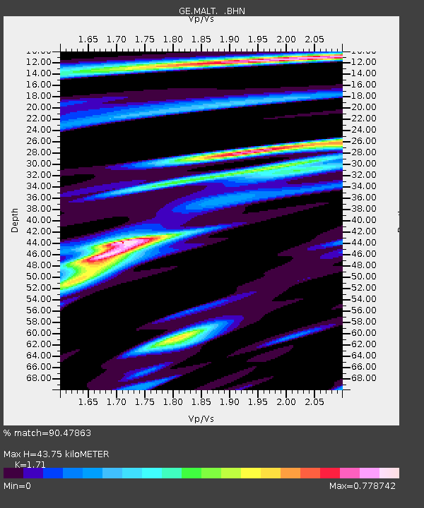
| Estimated Moho Depth: |
43.75 km |
| Estimated Crust Vp/Vs: |
1.71 |
| Assumed Crust Vp: |
6.35 km/s |
| Estimated Crust Vs: |
3.713 km/s |
| Estimated Crust Poisson's Ratio: |
0.24 |
|
| Radial Match: |
90.47863 % |
| Radial Bump: |
400 |
| Transverse Match: |
81.58632 % |
| Transverse Bump: |
400 |
| SOD ConfigId: |
2475 |
| Insert Time: |
2010-03-09 06:50:18.113 +0000 |
| GWidth: |
2.5 |
| Max Bumps: |
400 |
| Tol: |
0.001 |
|

Signal To Noise
| Channel | StoN | STA | LTA |
| GE:MALT: :BHN:20050723T07:46:10.941021Z | 13.333831 | 3.4635403E-7 | 2.597558E-8 |
| GE:MALT: :BHE:20050723T07:46:10.941021Z | 8.370877 | 2.8963805E-7 | 3.460068E-8 |
| GE:MALT: :BHZ:20050723T07:46:10.941021Z | 27.936584 | 1.2625055E-6 | 4.5191836E-8 |
| Arrivals |
| Ps | 5.0 SECOND |
| PpPs | 18 SECOND |
| PsPs/PpSs | 23 SECOND |


