You are here: Home > Network List > N4 - Central and EAstern US Network Stations List
> Station N47A Urbana, IN, USA > Earthquake Result Viewer
N47A Urbana, IN, USA - Earthquake Result Viewer
| Earthquake location: |
Leeward Islands |
| Earthquake latitude/longitude: |
16.7/-60.8 |
| Earthquake time(UTC): |
2021/03/26 (085) 04:51:39 GMT |
| Earthquake Depth: |
26 km |
| Earthquake Magnitude: |
5.8 mww |
| Earthquake Catalog/Contributor: |
NEIC PDE/us |
|
| Network: |
N4 Central and EAstern US Network |
| Station: |
N47A Urbana, IN, USA |
| Lat/Lon: |
40.88 N/85.69 W |
| Elevation: |
252 m |
|
| Distance: |
32.3 deg |
| Az: |
323.343 deg |
| Baz: |
131.006 deg |
| Ray Param: |
0.07869341 |
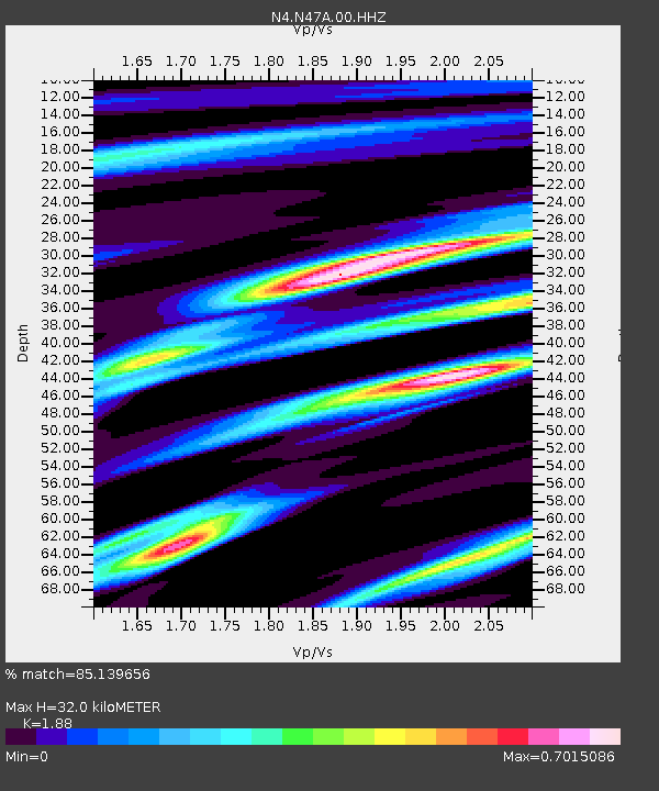
| Estimated Moho Depth: |
32.0 km |
| Estimated Crust Vp/Vs: |
1.88 |
| Assumed Crust Vp: |
6.498 km/s |
| Estimated Crust Vs: |
3.456 km/s |
| Estimated Crust Poisson's Ratio: |
0.30 |
|
| Radial Match: |
85.139656 % |
| Radial Bump: |
209 |
| Transverse Match: |
67.10169 % |
| Transverse Bump: |
379 |
| SOD ConfigId: |
24334971 |
| Insert Time: |
2021-04-09 05:10:53.838 +0000 |
| GWidth: |
2.5 |
| Max Bumps: |
400 |
| Tol: |
0.001 |
|

Signal To Noise
| Channel | StoN | STA | LTA |
| N4:N47A:00:HHZ:20210326T04:57:35.929996Z | 8.509727 | 1.4348049E-6 | 1.6860763E-7 |
| N4:N47A:00:HH1:20210326T04:57:35.929996Z | 3.817266 | 5.75597E-7 | 1.5078777E-7 |
| N4:N47A:00:HH2:20210326T04:57:35.929996Z | 4.4858537 | 6.8320526E-7 | 1.5230218E-7 |
| Arrivals |
| Ps | 4.7 SECOND |
| PpPs | 13 SECOND |
| PsPs/PpSs | 18 SECOND |


