You are here: Home > Network List > NM - Cooperative New Madrid Seismic Network Stations List
> Station UTMT Martin, TN > Earthquake Result Viewer
UTMT Martin, TN - Earthquake Result Viewer
| Earthquake location: |
Leeward Islands |
| Earthquake latitude/longitude: |
16.7/-60.8 |
| Earthquake time(UTC): |
2021/03/26 (085) 04:51:39 GMT |
| Earthquake Depth: |
26 km |
| Earthquake Magnitude: |
5.8 mww |
| Earthquake Catalog/Contributor: |
NEIC PDE/us |
|
| Network: |
NM Cooperative New Madrid Seismic Network |
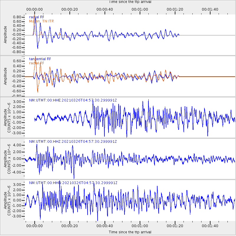
| Station: |
UTMT Martin, TN |
| Lat/Lon: |
36.35 N/88.86 W |
| Elevation: |
110 m |
|
| Distance: |
31.7 deg |
| Az: |
313.668 deg |
| Baz: |
120.821 deg |
| Ray Param: |
0.078962795 |
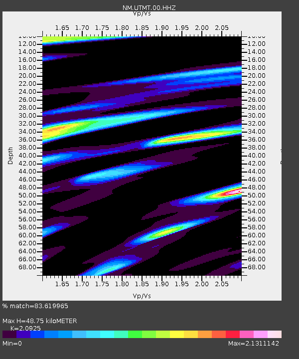
| Estimated Moho Depth: |
48.75 km |
| Estimated Crust Vp/Vs: |
2.09 |
| Assumed Crust Vp: |
6.444 km/s |
| Estimated Crust Vs: |
3.08 km/s |
| Estimated Crust Poisson's Ratio: |
0.35 |
|
| Radial Match: |
83.619965 % |
| Radial Bump: |
400 |
| Transverse Match: |
69.42899 % |
| Transverse Bump: |
382 |
| SOD ConfigId: |
24334971 |
| Insert Time: |
2021-04-09 05:12:30.091 +0000 |
| GWidth: |
2.5 |
| Max Bumps: |
400 |
| Tol: |
0.001 |
|
Signal To Noise
| Channel | StoN | STA | LTA |
| NM:UTMT:00:HHZ:20210326T04:57:30.299991Z | 9.593028 | 1.9330057E-6 | 2.0150111E-7 |
| NM:UTMT:00:HHN:20210326T04:57:30.299991Z | 2.60622 | 1.3123216E-6 | 5.0353447E-7 |
| NM:UTMT:00:HHE:20210326T04:57:30.299991Z | 3.1753583 | 1.4476104E-6 | 4.5588885E-7 |
| Arrivals |
| Ps | 8.8 SECOND |
| PpPs | 22 SECOND |
| PsPs/PpSs | 31 SECOND |


