You are here: Home > Network List > NM - Cooperative New Madrid Seismic Network Stations List
> Station X502 Temporary Arkansas > Earthquake Result Viewer
X502 Temporary Arkansas - Earthquake Result Viewer
| Earthquake location: |
Leeward Islands |
| Earthquake latitude/longitude: |
16.7/-60.8 |
| Earthquake time(UTC): |
2021/03/26 (085) 04:51:39 GMT |
| Earthquake Depth: |
26 km |
| Earthquake Magnitude: |
5.8 mww |
| Earthquake Catalog/Contributor: |
NEIC PDE/us |
|
| Network: |
NM Cooperative New Madrid Seismic Network |
| Station: |
X502 Temporary Arkansas |
| Lat/Lon: |
35.49 N/92.39 W |
| Elevation: |
344 m |
|
| Distance: |
33.8 deg |
| Az: |
309.772 deg |
| Baz: |
115.484 deg |
| Ray Param: |
0.07803337 |
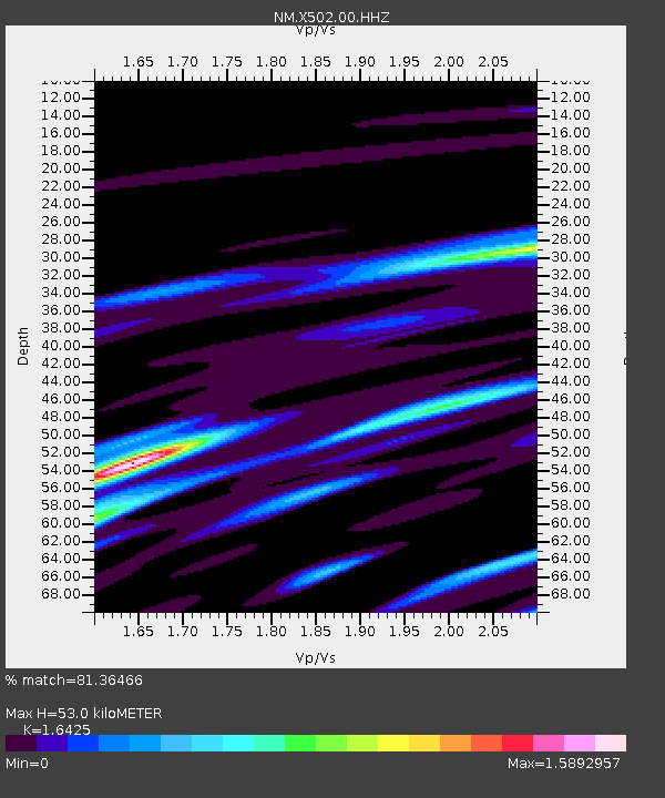
| Estimated Moho Depth: |
53.0 km |
| Estimated Crust Vp/Vs: |
1.64 |
| Assumed Crust Vp: |
6.498 km/s |
| Estimated Crust Vs: |
3.956 km/s |
| Estimated Crust Poisson's Ratio: |
0.21 |
|
| Radial Match: |
81.36466 % |
| Radial Bump: |
346 |
| Transverse Match: |
34.47414 % |
| Transverse Bump: |
351 |
| SOD ConfigId: |
24334971 |
| Insert Time: |
2021-04-09 05:12:30.253 +0000 |
| GWidth: |
2.5 |
| Max Bumps: |
400 |
| Tol: |
0.001 |
|

Signal To Noise
| Channel | StoN | STA | LTA |
| NM:X502:00:HHZ:20210326T04:57:48.769992Z | 8.552398 | 1.6761351E-6 | 1.9598424E-7 |
| NM:X502:00:HHN:20210326T04:57:48.769992Z | 2.5864964 | 5.975883E-7 | 2.3104161E-7 |
| NM:X502:00:HHE:20210326T04:57:48.769992Z | 4.2856255 | 1.4175293E-6 | 3.3076373E-7 |
| Arrivals |
| Ps | 5.7 SECOND |
| PpPs | 20 SECOND |
| PsPs/PpSs | 25 SECOND |


