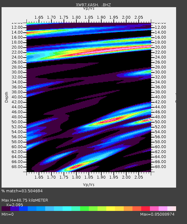
KASH XW.KASH - Earthquake Result Viewer

Earthquake location: Minahassa Peninsula, Sulawesi
Earthquake latitude/longitude: 0.3/122.5
Earthquake time(UTC): 1998/09/21 (264) 06:52:41 GMT
Earthquake Depth: 147 km
Earthquake Magnitude: 6.1 MB, 6.0 UNKNOWN, 5.9 MW
Earthquake Catalog/Contributor: WHDF/NEIC
Network: XW Tien Shan Continental Dynamics
Station: KASH XW.KASH
Lat/Lon: 39.52 N/75.92 E
Elevation: 1310 m
Distance: 57.7 deg
Az: 318.351 deg
Baz: 120.781 deg
Ray Param: 0.062888645
Estimated Moho Depth: 48.75 km
Estimated Crust Vp/Vs: 2.10
Assumed Crust Vp: 6.472 km/s
Estimated Crust Vs: 3.089 km/s
Estimated Crust Poisson's Ratio: 0.35
Radial Match: 83.584694 %
Radial Bump: 400
Transverse Match: 78.49386 %
Transverse Bump: 400
SOD ConfigId: 4480
Insert Time: 2010-02-26 15:27:40.448 +0000
GWidth: 2.5
Max Bumps: 400
Tol: 0.001

Signal To Noise

ChannelStoNSTALTA
XW:KASH: :BHZ:19980921T07:01:45.350Z3.19522763.6155538E-71.1315481E-7
XW:KASH: :BHN:19980921T07:01:45.350Z0.74306571.3084068E-71.7608222E-7
XW:KASH: :BHE:19980921T07:01:45.350Z1.04859481.8124653E-71.7284707E-7
Arrivals
Ps8.6 SECOND
PpPs22 SECOND
PsPs/PpSs31 SECOND